• Laser & Optoelectronics Progress
  • Vol. 60, Issue 10, 1028001 (2023)
Chao Xia1,2, Honglian Huang1,*, Xiaobing Sun1, Xiao Liu1..., Haixiao Yu1,2 and Yichen Wei1,2|Show fewer author(s)
Author Affiliations
  • 1Key Laboratory of Optical Calibration and Characterization, Anhui Institute of Optics and Fine Mechanics, Hefei Institutes of Physical Science, Chinese Academy of Sciences, Hefei 230031, Anhui, China
  • 2University of Science and Technology of China, Hefei 230026, Anhui, China
  • show less
    DOI: 10.3788/LOP220608 Cite this Article Set citation alerts
    Chao Xia, Honglian Huang, Xiaobing Sun, Xiao Liu, Haixiao Yu, Yichen Wei. Atmospheric Correction in Mountainous Areas Based on Environmental Satellite CCD Images[J]. Laser & Optoelectronics Progress, 2023, 60(10): 1028001 Copy Citation Text show less
    Normalized spectral response curves of each spectrum segment of CCD3 camera
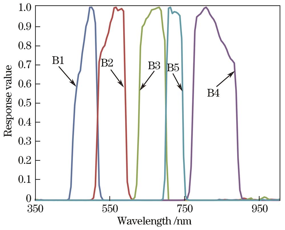
    Fig. 1. Normalized spectral response curves of each spectrum segment of CCD3 camera
    Atmospheric correction process of remote sensing images in mountainous areas based on Environmental Satellite
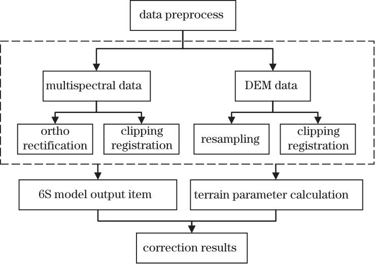
    Fig. 2. Atmospheric correction process of remote sensing images in mountainous areas based on Environmental Satellite
    Remote sensing image and DEM data after pretreatment. (a) Multispectral remote sensing image of region A to be corrected; (b) DEM matched by region A; (c) multispectral remote sensing image of region B to be corrected; (d) DEM matched by region B
    Fig. 3. Remote sensing image and DEM data after pretreatment. (a) Multispectral remote sensing image of region A to be corrected; (b) DEM matched by region A; (c) multispectral remote sensing image of region B to be corrected; (d) DEM matched by region B
    Topographic factors of regions A and B. (a) Slope of region A; (b) aspect of region A; (c) sky view factor of region A; (d) illumination angle of region A; (e) slope of region B; (f) aspect of region B; (g) sky view factor of region B; (h) illumination angle of region B
    Fig. 4. Topographic factors of regions A and B. (a) Slope of region A; (b) aspect of region A; (c) sky view factor of region A; (d) illumination angle of region A; (e) slope of region B; (f) aspect of region B; (g) sky view factor of region B; (h) illumination angle of region B
    Images of regions A and B before and after correction. (a) Image of region A before correction; (b) image of region A after correction; (c) image of region B before correction; (d) image of region B after correction
    Fig. 5. Images of regions A and B before and after correction. (a) Image of region A before correction; (b) image of region A after correction; (c) image of region B before correction; (d) image of region B after correction
    Image entropy of region B before and after correction
    Fig. 6. Image entropy of region B before and after correction
    Image contrast of region B before and after correction
    Fig. 7. Image contrast of region B before and after correction
    Image definition of region B before and after correction
    Fig. 8. Image definition of region B before and after correction
    Regression curves of cosine values of illumination angle and images in different bands before and after correction. (a) Band 1 before correction; (b) band 1 after correction; (c) band 2 before correction; (d) band 2 after correction; (e) band 3 before correction; (f) band 3 after correction
    Fig. 9. Regression curves of cosine values of illumination angle and images in different bands before and after correction. (a) Band 1 before correction; (b) band 1 after correction; (c) band 2 before correction; (d) band 2 after correction; (e) band 3 before correction; (f) band 3 after correction
    Spectral curves of different features before and after correction. (a) Withered grass; (b) Chinese pine;(c)fruit tree
    Fig. 10. Spectral curves of different features before and after correction. (a) Withered grass; (b) Chinese pine;(c)fruit tree
    BandCentral wavelength /nmWavelength range /nmProbe paramsPolarization
    Band 1410400-420AerosolYes
    Band 2443433-453AerosolYes
    Band 3555545-565AerosolYes
    Band 4670660-680AerosolYes
    Band 5865845-885Aerosol,steam,cloudYes
    Band 6910900-920SteamYes
    Band 713801360-1400Cirrus recognitionYes
    Band 816101580-1640Aerosol,surfaceYes
    Band 922502210-2290Aeroso,surfaceYes
    Table 1. Band setting of atmospheric calibrator
    Geometry parameterSolar zenith /(°)22.160191
    Solar azimuth /(°)151.045525
    Satellite zenith /(°)8.911552
    Satellite azimuth /(°)103.483838
    Observation date2021-05-22
    Atmospheric parameterAtmosphere modelMidlatitude summer
    Aerosol modelMainland
    Aerosol concentrationregion A:0.223
    region B:0.217
    Sensor parameterTarget altitude /kmregion A:1.6845
    region B:0.9555
    Band range /nmBand 1:450-520
    Band 2:520-590
    Band 3:630-690
    Band 4:770-890
    Band 5:690-730
    Table 2. 6S model input parameters
    BandCentral wavelength /nmWithered grassChinese pineFruit tree
    OriginalCorrectedOriginalCorrectedOriginalCorrected
    Band 14851.490.292.070.191.670.27
    Band 25552.970.112.940.072.250.03
    Band 36600.50.080.70.210.460.21
    Band 47101.310.431.370.490.790.41
    Band 58100.550.150.410.160.110.08
    Table 3. Error analysis of different features before and after correction
    Chao Xia, Honglian Huang, Xiaobing Sun, Xiao Liu, Haixiao Yu, Yichen Wei. Atmospheric Correction in Mountainous Areas Based on Environmental Satellite CCD Images[J]. Laser & Optoelectronics Progress, 2023, 60(10): 1028001
    Download Citation