
Yaran LI, Haochen BAO, Shengli SUN. Peering into Aerospace Infrared Remote Sensing Detection Technology:Evolutionary Patterns and Development Trends[J]. AEROSPACE SHANGHAI, 2024, 41(3): 25
- AEROSPACE SHANGHAI
- Vol. 41, Issue 3, 25 (2024)
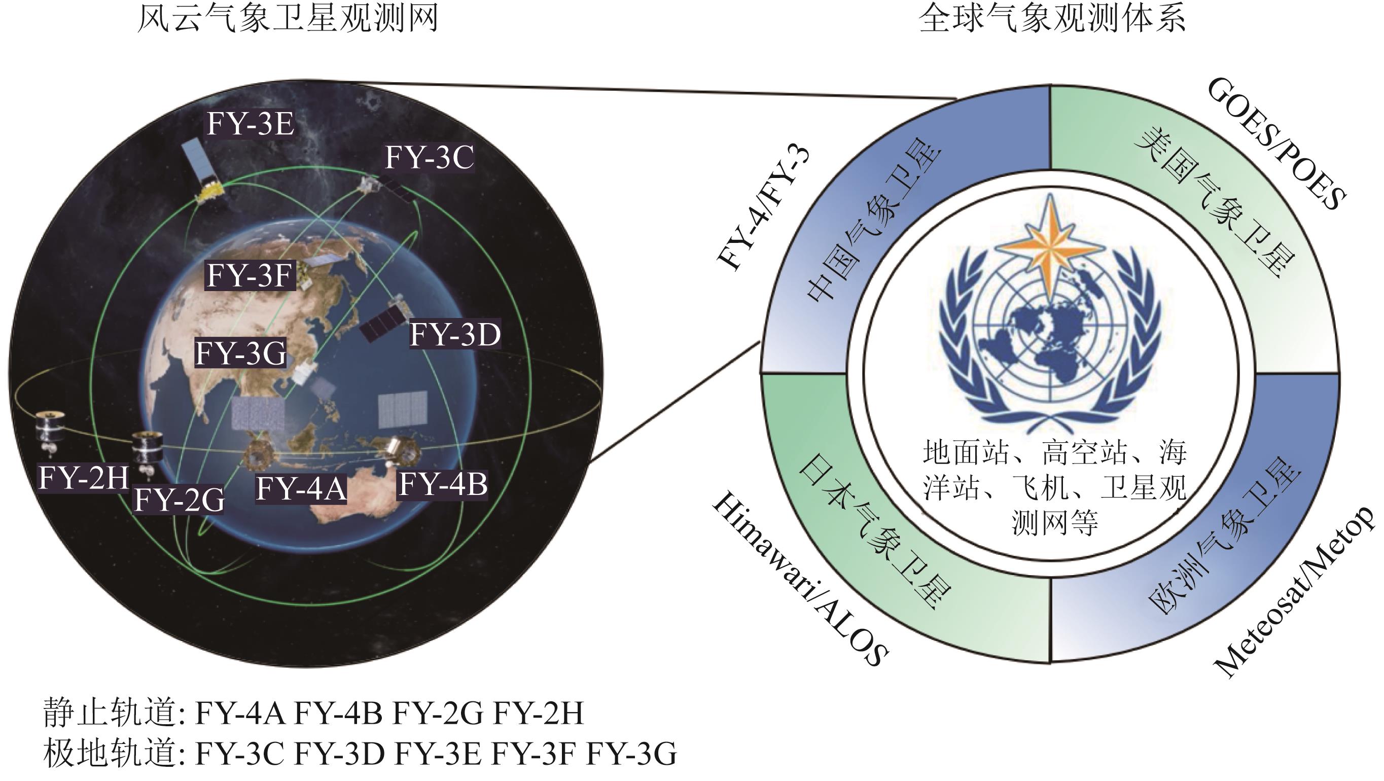
Fig. 1. Observation network of Fengyun meteorological satellites (In the figure ,FY is the abbreviation for Fengyun meteorological satellite.FY-4A refers to Fengyun-4A satellite ,and the abbreviation rule is the same for other Fengyun meteorological satellites.Geostationary Operational Environmental Satellite (GOES ),Polar Orbit Environment Satellite (POES ),Meteorological Satellite (Meteosat ),Meteorological Operational Satellite Program (Metop ),Himawari meteorological satellite (Himawari ),and Advanced Land Observing Satellite (ALOS ))
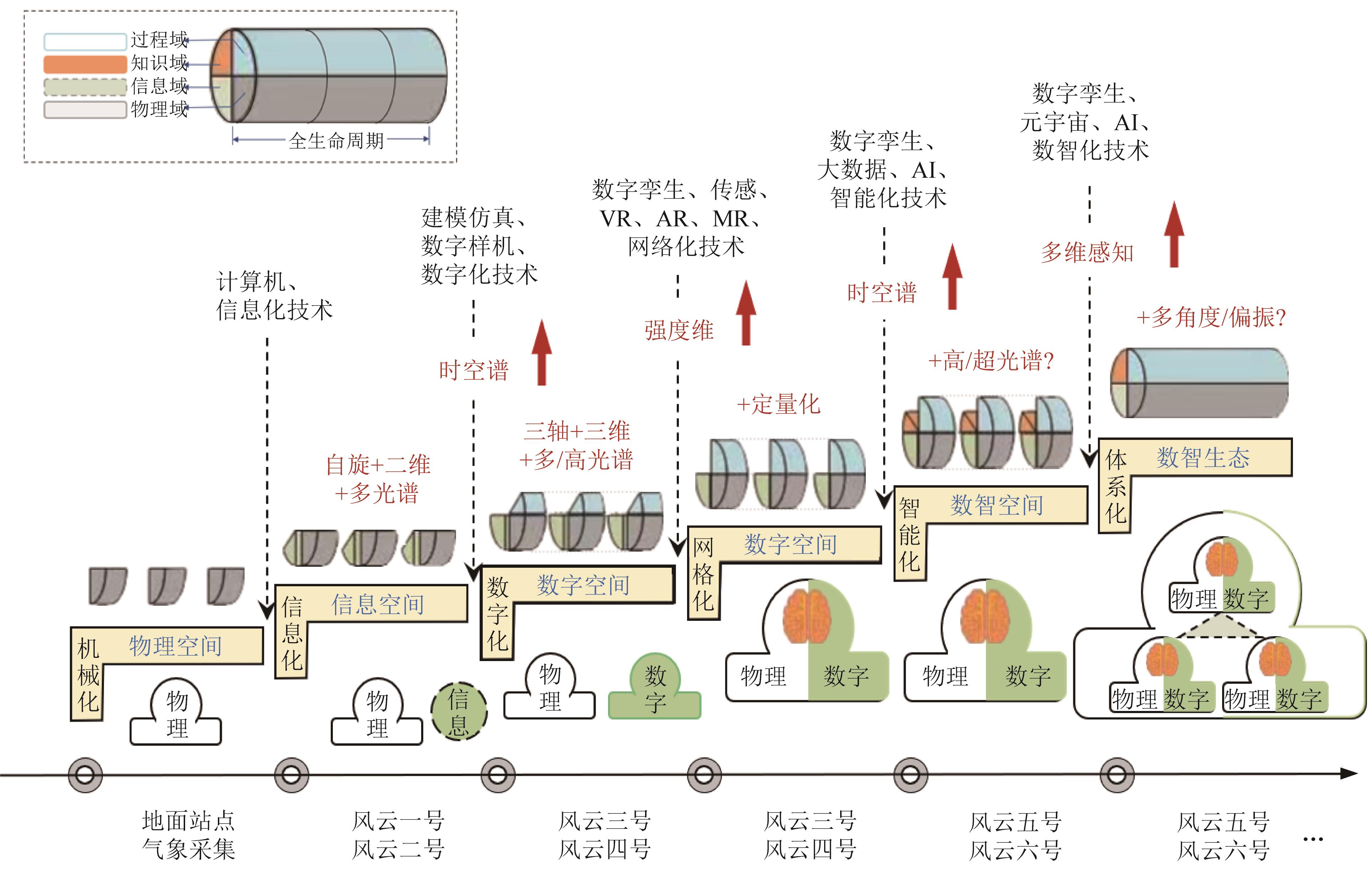
Fig. 2. Technical evolution roadmap of Fengyun meteorological satellites (In the figure ,there are Virtual Reality (VR ),Augmented Reality (AR ),Mixed Reality (MR ),and Artificial Intelligence (AI ))
Fig. 3. Constraint diagram of the capability of infrared remote sensing technology
Fig. 4. Evolution diagram of the infrared hyperspectral remote sensing technology (In the figure ,Aviation Imaging Spectrometer (AIS-1 ),Airborne Visible/InfraRed Imaging Spectrometer (AVIRIS ),Earth Observing-1/Hyperion Imaging Spectrometer (EO-1/Hyperion ),Compact High Resolution Imaging Spectrometer (CHRIS ),Environmental Satellite-1A (HJ-1-A ),Tiangong-1 (TG-1 ),DLR Earth Sensing Imaging Spectrometer (DESIS ),Environmental Mapping Spectrometer (EnMAP ),Gaofen-5/Advanced Hyperspectral Imager (GF-5/AHSI ),and Ziyuan-1 02E Satellite (ZY-1-02E ))
Fig. 5. Evolution diagram of the spaceborne thermal infrared remote sensing technology (In the figure ,Very High Resolution Radiometer (VHRR ),Advanced Very High Resolution Radiometer (AVHRR ),Moderate-Resolution Imaging Spectroradiometer (MODIS ),Landsat 7 Enhanced Thematic Mapper Plus (L7/ETM+ ),Fengyun-3A Visible and Infrared Radiometer (VIRR ),Landsat 8 Thermal Infrared Sensor (L8/TIRS ),NOAA-20 Visible Infrared Imaging Radiometer Suite (NOAA-20/VIIRS ),GF-5 Visible and Infrared Multispectral Imager (GF-5/VIMI ),HJ-2A Infrared Spectrometer (HJ-2A/IRS ),and SDGSAT-1 Thermal Infrared Sensor (SDGSAT-1/TIS ))
Fig. 6. Development history of infrared focal plane detectors
Fig. 7. Diagram of the perception ,storage ,and computation-integrated intelligent sensing technology based on bionics
Fig. 8. Intelligent manufacturing and remote sensing applications of satellites in the new era
Fig. 9. Development history of infrared target detection algorithms or models (The abbreviated algorithm names in the figure are as follows :Convolutional Neural Network (CNN ),Fast Region-based Convolutional Neural Network (Fast R-CNN ),You Only Look Once (YOLO ),You Only Look Once version 8 (YOLOv8 ),Region-based Convolutional Neural Network (R-CNN ),and Single Shot MultiBox Detector (SSD ))
|
Table 1. Development timeline of Fengyun meteorological satellites
|
Table 2. Main technical specifications of the shortwave infrared mercury cadmium telluride detectors


Set citation alerts for the article
Please enter your email address

© Copyright 2018-2021 | Chinese Laser Press. All Rights Reserved 沪ICP备15018463号-20