• Journal of Natural Resources
  • Vol. 35, Issue 10, 2401 (2020)
Guang-xin XIANG1,2,*, Jin-hao FU1,2, Li-ting ZENG1,2, Xing-xiang JIANG1,2, and Yi ZENG1,2
Author Affiliations
  • 1Hunan Key Lab of Land & Resource Evaluation & Utilization, Changsha 410007, China
  • 2Hunan Planning Institute of Land and Resources, Changsha 410007, China
  • show less
    DOI: 10.31497/zrzyxb.20201008 Cite this Article
    Guang-xin XIANG, Jin-hao FU, Li-ting ZENG, Xing-xiang JIANG, Yi ZENG. Demarcation technology of urban development boundary based on evaluation of carrying capacity of resources environment and suitability of land space development: A case study of the central city of Xiangtan county[J]. Journal of Natural Resources, 2020, 35(10): 2401 Copy Citation Text show less
    Technology roadmap of urban development boundary demarcation based on evaluations of carrying capacity of resources environment and suitability of land space development
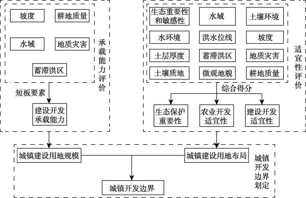
    Fig. 1. Technology roadmap of urban development boundary demarcation based on evaluations of carrying capacity of resources environment and suitability of land space development
    Suitability distribution of land space development and priority areas of ecology, agriculture and construction in Yisuhe town, Xiangtan county
    Fig. 2. Suitability distribution of land space development and priority areas of ecology, agriculture and construction in Yisuhe town, Xiangtan county
    Village kernel density and urban development boundary of the central city of Xiangtan
    Fig. 3. Village kernel density and urban development boundary of the central city of Xiangtan
    The relationship between urban development boundary and the current urban construction, river and road location in the central city of Xiangtan
    Fig. 4. The relationship between urban development boundary and the current urban construction, river and road location in the central city of Xiangtan
    指标指标分类分级
    坡度/(°)>25低(Ⅰ级)
    (15, 25]较低(Ⅱ级)
    (8, 15]中(Ⅲ级)
    (0, 8]高(Ⅴ级)
    水域河流、湖泊、水库等低(Ⅰ级)
    耕地质量耕地质量劣于评价区域平均利用等中(Ⅲ级)
    耕地质量优于评价区域平均利用等较低(Ⅱ级)
    地质灾害易发程度高易发区较低(Ⅱ级)
    中易发区中(Ⅲ级)
    低易发区较高(Ⅳ级)
    其他高(Ⅴ级)
    蓄滞洪区蓄滞洪区范围内低(Ⅰ级)
    Table 1. Index and classification standard of land resources availability in construction development
    类型指标指标分类分值(JiXk权重(wk
    禁止性
    指标
    生态重要性和敏感性生态极重要或极敏感区域0
    其他1
    水域河流、湖泊、水库等0
    其他1
    土壤环境劣于农用地土壤污染风险管制值 [按《土壤环境质量—农用地土壤污染风险管控标准(试行)》(GB15618-2018)]0
    优于农用地土壤污染风险管制值 [按《土壤环境质量—农用地土壤污染风险管控标准(试行)》(GB15618-2018)]1
    水环境劣于农田灌溉用水水质基本控制项目标准值 [按《农田灌溉水质标准》(GB5084-2005)]0
    优于农田灌溉用水水质基本控制项目标准值 [按《农田灌溉水质标准》(GB5084-2005)]1
    洪水位线河流、湖泊洪水位线以下0
    河流、湖泊洪水位线以上1
    坡度/(°)>250
    土层厚度/cm<300
    限制性
    指标
    生态重要性和敏感性高度重要或高度敏感200.2
    中等重要或中度敏感60
    一般重要/不重要或一般敏感/不敏感100
    坡度/(°)(15, 25]200.2
    (8, 15]60
    (2, 8]80
    [0, 2]100
    蓄滞洪区重要蓄滞洪区300.1
    一般蓄滞洪区50
    蓄滞洪保留区70
    非蓄滞洪区100
    地质灾害易发程度高易发区600.05
    中易发区80
    低易发区90
    其他100
    土层厚度/cm[30, 60)600.15
    [60, 90)80
    ≥ 90100
    土壤质地砾质土100.2
    壤质砂土、砂质壤土、砂质粘土、壤质粘土、粉砂质粘土、粘土50
    壤土、粉砂质壤土、砂质粘壤土、粘壤土、粉砂质粘壤土100
    微观地貌山肩、山顶100.1
    背坡30
    麓坡60
    趾坡、岗地90
    平原、台地100
    Table 2. Factors of suitability evaluation of agricultural production
    类型指标分类分值(JiXk权重
    禁止性
    指标
    生态重要性和敏感性生态极重要或极敏感区0
    其他区域1
    水域河流、湖泊、水库等0
    其他1
    洪水位线河流、湖泊洪水位线以下0
    河流、湖泊洪水位线以上1
    坡度/(°)>250
    限制性
    指标
    生态重要性和敏感性高度重要或高度敏感300.4
    中等重要或中度敏感60
    一般重要或一般敏感100
    耕地质量耕地质量高于评价区域平均利用等200.25
    耕地质量低于评价区域平均利用等60
    坡度大于25%,且小于等于46.63%(25°)100.25
    ≤ 25%100
    地质灾害易发程度高易发区400.05
    中易发区60
    低易发区80
    无地质灾害风险100
    蓄滞洪区蓄滞洪区200.05
    其他100
    Table 3. Factors of suitability evaluation of construction development
    边界内新增建设
    用地占用地类
    土地利用总体规划
    规模边界
    城市总体规划中心城区
    空间增长边界
    国土空间规划城镇
    开发边界
    林地30.08(含公益林)29.42(含公益林)49.72(全部为非公益林)
    耕地53.2650.94(含永久基本农田)21.02
    园地0.170.290.26
    采矿用地0.921.223.64
    坑塘水面8.718.6412.57
    其他类型的土地6.859.4912.79
    Table 4. The structure of new construction land occupation within the control boundaries of construction and development in the central city of Xiangtan (%)
    Guang-xin XIANG, Jin-hao FU, Li-ting ZENG, Xing-xiang JIANG, Yi ZENG. Demarcation technology of urban development boundary based on evaluation of carrying capacity of resources environment and suitability of land space development: A case study of the central city of Xiangtan county[J]. Journal of Natural Resources, 2020, 35(10): 2401
    Download Citation