• Laser & Optoelectronics Progress
  • Vol. 59, Issue 24, 2428002 (2022)
Bin Zhong1, Zhiyun Liu2,**, Xiangxin Li1,3,*, and Jiaying LÜ1
Author Affiliations
  • 1School of Land and Resources Engineering, Kunming University of Science and Technology, Kunming 650031, Yunan, China
  • 2Kunming Engineering Corporation Limited, Kunming 650000, Yunnan, China
  • 3Research Center for Application Engineering of Surveying and Mapping Technology in Plateau and Mountainous Areas, Kunming 650093, Yunnan, China
  • show less
    DOI: 10.3788/LOP202259.2428002 Cite this Article Set citation alerts
    Bin Zhong, Zhiyun Liu, Xiangxin Li, Jiaying LÜ. Ascending and Descending Time Series Interferometric Synthetic Aperture Radar Monitoring and Analysis of Landslide Deformation[J]. Laser & Optoelectronics Progress, 2022, 59(24): 2428002 Copy Citation Text show less
    Geographic location map of study area [base map uses global 30 m resolution AW3D30 digital elevation model (DEM) issued by Japan Aerospace Exploration Agency]
    Fig. 1. Geographic location map of study area [base map uses global 30 m resolution AW3D30 digital elevation model (DEM) issued by Japan Aerospace Exploration Agency]
    GPS reference point location and approximate distribution of landslide areas
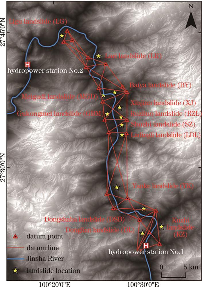
    Fig. 2. GPS reference point location and approximate distribution of landslide areas
    Annual average line-of-sight (LOS) deformation rate in study area (aescending)
    Fig. 3. Annual average line-of-sight (LOS) deformation rate in study area (aescending)
    Annual average LOS deformation rate in study area (descending)
    Fig. 4. Annual average LOS deformation rate in study area (descending)
    Annual average deformation rate of newly built (base map from Google Earth)
    Fig. 5. Annual average deformation rate of newly built (base map from Google Earth)
    GPS reference points and monitoring points distribution of Xinjian landslide (base map from Google Earth)
    Fig. 6. GPS reference points and monitoring points distribution of Xinjian landslide (base map from Google Earth)
    Comparison of LOS cumulative displacements of InSAR and GPS data
    Fig. 7. Comparison of LOS cumulative displacements of InSAR and GPS data
    Relationship between water level change of Fengke Reservoir and daily rainfall in Lijiang City and cumulative displacement of characteristic points of Xinjian landslide
    Fig. 8. Relationship between water level change of Fengke Reservoir and daily rainfall in Lijiang City and cumulative displacement of characteristic points of Xinjian landslide
    NumberParameterSAR basic parameter
    1Orbital directionSentinel-1A ascendingSentinel-1A descending
    2BandCC
    3Wavelength /m5.65.6
    4Revisit cycle /d1212
    5Heading angle /(°)347.4192.6
    6Incident angle /(°)41.939.5
    7Number of images3130
    8Coverage period2018.04.06-2019.04.132018.06.19-2019.06.14
    Table 1. Basic parameters of SAR data
    Point numberInSAR /mmGPS /mmD-value /mmRMSE /mm
    XJN327.7972.82-45.03
    XJ0424.2347.28-23.05
    XJ0580.0997.39-17.30
    XJ0690.8987.173.72
    XJ07103.9251.3852.5431.90
    XJ0959.0047.5411.46
    XJ1429.5216.3513.17
    XJ1793.09149.74-56.65
    XJ20115.02111.903.12
    Table 2. Comparison of LOS cumulative deformations of GPS and InSAR
    Bin Zhong, Zhiyun Liu, Xiangxin Li, Jiaying LÜ. Ascending and Descending Time Series Interferometric Synthetic Aperture Radar Monitoring and Analysis of Landslide Deformation[J]. Laser & Optoelectronics Progress, 2022, 59(24): 2428002
    Download Citation