• Acta Geographica Sinica
  • Vol. 75, Issue 7, 1373 (2020)
Xinyue LIANG1,2,5,*, Mengzhen XU2, Liqun LYU2,3, Yifei CUI2, and Fengbao ZHANG1,4
Author Affiliations
  • 1State Key Laboratory of Soil Erosion and Dryland Farming on the Loess Plateau, Institute of Soil and Water Conservation , CAS and Ministry of Water Resources, Yangling 712100, Shaanxi, China
  • 2State Key Laboratory of Hydroscience and Engineering, Tsinghua University, Beijing 100084, China
  • 3Beijing Engineering Research Center of Soil and Water Conservation, Beijing Forestry University, Beijing 100083, China
  • 4Institute of Soil and Water Conservation, Northwest A&F University, Yangling 712100, Shaanxi, China
  • 5University of Chinese Academy of Sciences, Beijing 100049, China
  • show less
    DOI: 10.11821/dlxb202007004 Cite this Article
    Xinyue LIANG, Mengzhen XU, Liqun LYU, Yifei CUI, Fengbao ZHANG. Geomorphological characteristics of debris flow gullies on the edge of the Qinghai-Tibet Plateau[J]. Acta Geographica Sinica, 2020, 75(7): 1373 Copy Citation Text show less
    Spatial distribution of debris flow disasters and earthquakes on the Qinghai-Tibet Plateau
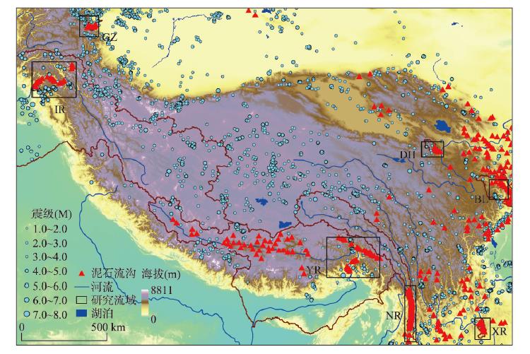
    Fig. 1. Spatial distribution of debris flow disasters and earthquakes on the Qinghai-Tibet Plateau
    Spatial distribution of debris flow gullies in the catchments and along the longitudinal profiles of the main streams
    Fig. 2. Spatial distribution of debris flow gullies in the catchments and along the longitudinal profiles of the main streams
    Clusters of debris flow gullies in the two-dimensional space obtained by NMDS
    Fig. 3. Clusters of debris flow gullies in the two-dimensional space obtained by NMDS
    Variation in morphologies among the three types of debris flow gullies
    Fig. 4. Variation in morphologies among the three types of debris flow gullies
    Characteristics of the three types of debris flow fans
    Fig. 5. Characteristics of the three types of debris flow fans
    Hack profiles and SL/K indices of nine rivers
    Fig. 6. Hack profiles and SL/K indices of nine rivers
    Hydrodynamic characteristics of the three types of debris flow gullies (a. Relation between TWI and slope; b. Relation between SPI and slope)
    Fig. 7. Hydrodynamic characteristics of the three types of debris flow gullies (a. Relation between TWI and slope; b. Relation between SPI and slope)
    地貌参数公式公式释意
    面积(A)通过ArcGIS水文分析模块提取面积是泥石流物源条件的反映,面积较大的沟谷有更多滑坡、崩塌为泥石流发生提供松散物质。
    坡度(S)S=tan-1HhLhHh为岩体垂直高度;Lh为水平长度。坡度反映松散物补给方式和汇流速度,坡度越陡,松散物越容易启动。
    主沟长度(L)通过ArcGIS水文分析模块提取主沟越长,越利于增加水量,接纳和搬运的松散碎屑物越多。
    比降(G)G=HLH为海拔变化;L为长度变化。比降反映沟道演化状况,表征泥石流沟水动力条件和物质输送能力,在一定范围内,比降越大越易爆发泥石流。
    高差(RA)RA=hmax-hminhmaxhmin分别是流域内的最高和最低海拔;RA表示切口深度和地表剥蚀程度,反映流域构造活动强度和能量条件。高差越大,越易发生泥石流。
    沟谷形状指数(Rf)Rf=AL2Rf反映沟谷的汇水和水动力条件。Rf大,沟道中洪峰流量越大,越有利松散物质的起动。
    面积—高程积分值(HI)HI=hmean-hminhmax-hminhmean表示是流域内的平均海拔。HI反映流域受侵蚀程度,HI越大,表明流域演化阶段越年轻,可蚀性越大。
    纵剖面形态指数(N)h=HlLNhl:纵剖面上某点与河口的高差及距离;HL:河源与河口之间的高差及水平距离;N反映泥石流发育地貌条件,可将泥石流分为幼年期、壮年期和老年期。
    沟壑密度(GD)GD=L/AL为沟谷河流的总长;GD反映流域发育的完善程度。沟壑密度越大的地区,不稳定面越多,边坡稳定性越弱,发生泥石流的可能性也越大
    植被覆盖度(FVC)FVC=(NDVI-NDVIsoil)(NDVIveg-NDVIsoil)NDVIsoil是裸土或者无植被覆盖区域的NDVI;NDVIveg是完全被植被覆盖的NDVI。通常植被覆盖度越高,坡面越稳定。
    Table 1. Main factors affecting the occurrence of debris flows
    Xinyue LIANG, Mengzhen XU, Liqun LYU, Yifei CUI, Fengbao ZHANG. Geomorphological characteristics of debris flow gullies on the edge of the Qinghai-Tibet Plateau[J]. Acta Geographica Sinica, 2020, 75(7): 1373
    Download Citation