• Laser & Optoelectronics Progress
  • Vol. 60, Issue 10, 1028007 (2023)
Jinlu Liu1, Deyong Sun1,2,*, Deyu Kong3, Xishan Pan3..., Hongbo Jiao4, Zhenghao Li1, Shengqiang Wang1,2 and Yijun He1,2|Show fewer author(s)
Author Affiliations
  • 1School of Marine Sciences, Nanjing University of Information Science & Technology, Nanjing 210044, Jiangsu , China
  • 2Key Laboratory of Space Ocean Remote Sensing and Application, Ministry of Natural Resources, Nanjing 210044, Jiangsu , China
  • 3Jiangsu Provincial Marine Environment Monitoring Engineering Technology Research Center, Nanjing 210044, Jiangsu , China
  • 4National Marine Data and Information Service, Tianjin 300171, China
  • show less
    DOI: 10.3788/LOP220584 Cite this Article Set citation alerts
    Jinlu Liu, Deyong Sun, Deyu Kong, Xishan Pan, Hongbo Jiao, Zhenghao Li, Shengqiang Wang, Yijun He. Shallow Water Depth Inversed Using Multispectral Satellite Based on Machine Learning[J]. Laser & Optoelectronics Progress, 2023, 60(10): 1028007 Copy Citation Text show less
    Study area. (a) South Andaman islands; (b) Kume-jima; (c) Mentawai islands; (d) Hateruma-jima
    Fig. 1. Study area. (a) South Andaman islands; (b) Kume-jima; (c) Mentawai islands; (d) Hateruma-jima
    Technology roadmap
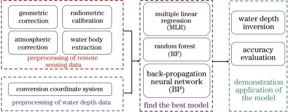
    Fig. 2. Technology roadmap
    Schematic of BP neural network
    Fig. 3. Schematic of BP neural network
    Schematic of random forest
    Fig. 4. Schematic of random forest
    Comparison of modeling accuracy. (a) MLR; (b) BP neural network; (c) RF
    Fig. 5. Comparison of modeling accuracy. (a) MLR; (b) BP neural network; (c) RF
    Comparison of validation accuracy. (a) MLR; (b) BP neural network; (c) RF
    Fig. 6. Comparison of validation accuracy. (a) MLR; (b) BP neural network; (c) RF
    Residual distribution. (a) MLR; (b) BP neural network; (c) RF
    Fig. 7. Residual distribution. (a) MLR; (b) BP neural network; (c) RF
    Precision comparison between sub-region model and whole-region model
    Fig. 8. Precision comparison between sub-region model and whole-region model
    Inversion result. (a) Hateruma-jima; (b) Kume-jima; (c) South Andaman islands; (d) Mentawai islands
    Fig. 9. Inversion result. (a) Hateruma-jima; (b) Kume-jima; (c) South Andaman islands; (d) Mentawai islands
    SensorWavelength /μmCentral wavelength /μmResolution /mImaging time
    Landsat-8 OLICoastal:0.430-0.450(B1Coastal:0.44030

    Hateruma-jima

    2013-06-05

    Kume-jima

    2015-12-13

    South Andaman

    2021-03-10

    Mentawai

    2019-05-02,

    2019-05-27,2019-01-26

    B:0.450-0.510(B2B:0.480
    G:0.550-0.590(B3G:0.570
    R:0.640-0.670(B4R:0.655
    NIR:0.850-0.880(B5NIR:0.865
    SWIR1:1.570-1.650(B6SWIR1:1.610
    SWIR2:2.110-2.290(B7SWIR2:2.200
    Table 1. Data source introduction
    ModelMAE /mMAPE /%R2
    MLR2.3735.480.68
    BP1.9317.120.76
    RF1.019.020.93
    Table 2. Comparison of modeling accuracy of all models
    ModelMAE /mMAPE /%R2
    MLR2.4525.380.66
    BP2.0519.430.74
    RF1.9418.290.75
    Table 3. Comparison of validation accuracy of all models
    IndexRegionSouth AndamanHateruma-jimaKume-jimaMentawai
    R2Sub-region0.740.870.710.64
    Whole-region0.740.870.720.66
    MAE /mSub-region1.951.342.301.78
    Whole-region1.951.362.111.80
    MAPE /%Sub-region18.3211.6023.0318.12
    Whole-region18.3711.4021.1916.79
    Table 4. Precision comparison of sub-region model and whole-region model
    Jinlu Liu, Deyong Sun, Deyu Kong, Xishan Pan, Hongbo Jiao, Zhenghao Li, Shengqiang Wang, Yijun He. Shallow Water Depth Inversed Using Multispectral Satellite Based on Machine Learning[J]. Laser & Optoelectronics Progress, 2023, 60(10): 1028007
    Download Citation