Journals >Remote Sensing Technology and Application
Contents

2024
Volume: 39 Issue 5
23 Article(s)
Export citation format

Review of Forest Age Datasets and Their Estimation Methods
Wenjie CHEN, Yang CHEN, and Jiangzhou XIA
Forest age is an important characteristic parameter of forest ecosystem, and it is of great significance to accurately estimate carbon storage and carbon sink of forest ecosystem. However, at present, there are few reviews on the age datasets and its estimation algorithm, so this paper systematically summarizes and anaForest age is an important characteristic parameter of forest ecosystem, and it is of great significance to accurately estimate carbon storage and carbon sink of forest ecosystem. However, at present, there are few reviews on the age datasets and its estimation algorithm, so this paper systematically summarizes and analyzes the existing forest age datasets, which were divided into global and regional forest age datasets according to the spatial coverage of the data. Then, we analyzed the algorithms of forest age datasets and their advantages and disadvantages. Research has shown that (1) The forest age algorithms mainly include the downscaling statistical method, relationship equations between forest age and forest structure parameters, forest disturbance detection algorithms and machine learning algorithms (such as random forest algorithm). (2) The advantage of the downscaling algorithm is simple and easy to use, but its main disadvantage is that the saturation of normalized differential vegetation index will underestimate the age of the old-growth forest. The advantage of the relationship model between forest age and forest structure parameters is that the high-precision remote sensing data of tree height or biomass data can reflect the spatial heterogeneity characteristics of forest age, and the forest growth model has a theoretical basis. But the disadvantage is that the results are restricted by the accuracy of forest or tree species distribution map, and the influence factors of forest growth are not considered comprehensively. The advantage of forest disturbance monitoring algorithm is that mature algorithms can be used to detect forest disturbance and infer the change of forest age, but the disadvantage is that the forest age must be combined with other methods to obtain the age of old forest. The advantage of random forest algorithm model is that the model is easy to build, does not need to set specific statistical assumptions and model forms, and doesn’t rely on forest type map or tree species distribution map. The disadvantage of this method is that it is restricted by the numbers and the spatial distribution representation of the model training samples. (3) Forest inventory data and remote sensing data are important data for forest age estimation. Forest age has important application prospects in ecological model driving, forest management and carbon neutrality. In the future, the research of forest age should strengthen the ground observation of forest age, combine the advantages of remote sensing data, and use a variety of machine learning algorithms to develop high spatial and temporal resolution forest age data..
Remote Sensing Technology and Application
- Publication Date: Oct. 20, 2024
- Vol. 39, Issue 5, 1039 (2024)


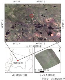
Research on the Inversion Method of Desert Grassland Fractional Vegetation Cover based on Collaborative UAV-Satellite Remote Sensing
Kexin NING, Chenxi SUN, Huawei WAN, and Yanmin SHUAI
Grassland Fractional Vegetation Cover is an important ecological parameter for evaluating the health status of grassland and monitoring environmental changes. At present, the extraction of Fractional Vegetation Cover at large regional scale is mainly based on satellite remote sensing data, and Unmanned Aerial Vehicle RGrassland Fractional Vegetation Cover is an important ecological parameter for evaluating the health status of grassland and monitoring environmental changes. At present, the extraction of Fractional Vegetation Cover at large regional scale is mainly based on satellite remote sensing data, and Unmanned Aerial Vehicle Remote Sensing (UAVRS) data, as a supplementary means of estimating grassland cover from satellite data, can improve the accuracy of model estimation. Based on the UAVRS data and BJ3 satellite data, three vegetation cover inversion methods, namely regression analysis method, pixel dichotomy method and random forest were used to invert and validate the vegetation cover of desert grassland in Otog Banner. The results showed that the best inversion model among the regression analysis models established by the vegetation index was the quadratic polynomial model of Normalized Difference Vegetation Index (NDVI), with R2=0.752; the R2 and RMSE obtained from the random forest model directly using the waveband values of UAVRS data were 0.893 and 0.072, compared with the quadratic polynomial model of NDVI and the pixel dichotomy model, R2 is improved by 0.141 and 0.151. Using the UAVRS data and the random forest method, it is possible to quickly and accurately obtain the vegetation cover of the study area on the satellite scale, which can provide support for the inversion of desert grassland vegetation cover in the large region..
Remote Sensing Technology and Application
- Publication Date: Oct. 20, 2024
- Vol. 39, Issue 5, 1054 (2024)
Research on Optical Characterization and Remote Sensing Identification of Typical Black and Odorous Water in Rural Areas
Li FU, Ge LIU, Kaishan SONG, and Yongjin CHEN
Black and odorous water occur frequently in rural China, and research into monitoring them by employing remote sensing technology has only recently begun, with many technical issues to be resolved.The samples were collected in rural areas of Jilin, Yunnan, and Guangxi provinces for this study, and 75 water samples fromBlack and odorous water occur frequently in rural China, and research into monitoring them by employing remote sensing technology has only recently begun, with many technical issues to be resolved.The samples were collected in rural areas of Jilin, Yunnan, and Guangxi provinces for this study, and 75 water samples from black and odorous water and 85 water samples from normal water were collected between 2021 and 2022, and their water quality parameters as well as optical properties were analyzed separately. We analyzed the image spectral characteristics of black and odorous water and normal water using GF-2 images, and observed that the reflectance of rural black and odorous water has an increasing trend in the red and near-infrared bands, whereas the reflectance of red and green bands was very low and the difference was small. Based on the two typical spectral characteristics of black and odorous water, the MBOI (Multi-spectral black and odorous water index) was developed, with a high identification accuracy. The following are the main research findings: (1) Black and odorous water have a higher concentration of total suspended particulate matter than normal water, and the concentration of organic carbon in black and odorous water bodies is 1.82 times higher compared to normal water. (2) At 440 nm, the absorption coefficients of all the materials, including algal particulate matter, non-pigmented particulate matter, and colored dissolved organic matter of black and odorous water were greater than those of normal water. (3) The data modeling and model verification are carried out by using the spectral reflectance data of the image after Rayleigh correction. When the MBOI value is between 0 and 0.18, it is determined as a black and odorous water body, and the model accuracy meets the requirements of black and odorous water body recognition..
Remote Sensing Technology and Application
- Publication Date: Oct. 20, 2024
- Vol. 39, Issue 5, 1064 (2024)
Two-stage Grassland Degradation Indicator Species Classification based on Improved Unet Model for UAV Images
Zhicheng CHEN, Huawei WAN, Fengming WAN, Jixi GAO... and Bin YANG|Show fewer author(s)
Aiming at the problems of small plant size of degraded indicator species and mixed pixels caused by similar morphological characteristics between grass species, a two-stage classification method based on object detection and semantic segmentation is proposed according to the obtained low-altitude UAV data. Secondly, thAiming at the problems of small plant size of degraded indicator species and mixed pixels caused by similar morphological characteristics between grass species, a two-stage classification method based on object detection and semantic segmentation is proposed according to the obtained low-altitude UAV data. Secondly, the segmentation model is lightweight improved. The RepVGG network with structural reparameterization is used to replace the Unet backbone network. The efficient channel attention mechanism ECA is introduced in the coding stage, and the feature extraction ability of the model is improved in the down-sampling link to achieve lightweight feature extraction. The block structure uses the ESE module to avoid the loss of channel information. The improved segmentation model has a good classification effect on the two types of grassland degradation indicator species of Artemisia frigida and Convolvulus ammannii in the typical grassland of Xilinhot. The MIoU can reach 0.91, which is about 0.11 higher than the original Unet model. The experimental results show that the UAV data and the two-stage classification method can classify the grassland degradation indicator species well, and the proposed lightweight improved model has a good effect..
Remote Sensing Technology and Application
- Publication Date: Oct. 20, 2024
- Vol. 39, Issue 5, 1075 (2024)
Evaluation Method and Application of River Physical Habitat Health in Hainan Island Rivers
Ziwei MA, Xiaodong MU, Taotao HAN, Jiceng XU, and Bowei CHEN
Tropical islands are among the most biodiverse regions on Earth, with the rivers that are shorter and more diverse than continental rivers. It is crucial to assess the physical habitat health of tropical island rivers for biodiversity protection, water resources management and economic development. At present, the healTropical islands are among the most biodiverse regions on Earth, with the rivers that are shorter and more diverse than continental rivers. It is crucial to assess the physical habitat health of tropical island rivers for biodiversity protection, water resources management and economic development. At present, the health of river physical habitat is mostly assessed using monitoring points and quadrats, which do not take into account representativeness, convenience, or safety. It is difficult to accurately and completely reflect the status of river physical habitat, and it is time-consuming and laborious. The physical habitat health evaluation index system of tropical island rivers was constructed applying remote sensing technique, with the major rivers in the Nandu River basin, Changhua River basin and Wanquan River Basin of Hainan Island serving as the research objects. The physical habitat health evaluation of 27 rivers in the three river basins was first and comprehensively assessed using hierarchical analysis and expert scoring methods. The results indicated that: (1)The Nandu River Basin, Changhua River Basin and Wanquan River Basin are mainly made up of forest and farmland ecosystems, with the farmland ecosystems accounting for the largest proportion in the entire basin. (2)The vegetation coverage in the riverbank zone of the entire watershed is generally high, reaching over 70%, and is primarily composed of artificial economic forests. The overall natural shoreline rate is low, with an average rate of 41.93%, and the human activities have a significant impact on the riparian zone. (3)The physical habitat evaluation of rivers in the three major basins predominantly falls into a sub-healthy state, followed by an unhealthy state. Based on the current state of ecological and environmental protection in Hainan, relevant research can provide data support for the accurate implementation of ecological protection and governance in the basin, as well as a reference for setting thresholds for relevant evaluation criteria such as water ecological assessment in tropical islands..
Remote Sensing Technology and Application
- Publication Date: Oct. 20, 2024
- Vol. 39, Issue 5, 1085 (2024)

Integrated Organization and Management of Ecological Environment Monitoring Data based on Geohash and Administrative Division Double-layer Nested Grid
Leilei SHI, Yue WU, Tuo WANG, Fei CAO, and Jixi GAO
Ecological environment monitoring is essential for ecological environment protection and supervision by providing reliable data. Effective integration and management of the monitoring data are fundamental for mining their potential value. However, the substantial volume, diverse sources, and high value of ecological enEcological environment monitoring is essential for ecological environment protection and supervision by providing reliable data. Effective integration and management of the monitoring data are fundamental for mining their potential value. However, the substantial volume, diverse sources, and high value of ecological environmental monitoring data present enormous challenges, such as differing standards and reference systems, which complicate data integration and sharing. In response to these issues, this paper proposes a mechanism of dual-layer embedding grid network hybrid indexing based on Geohash and administrative divisions. This approach promotes the integrated organization and management of various ecological environmental monitoring data and meets the storage and rapid retrieval needs of extensive, multi-source, and heterogeneous datasets. Based on this constructed mechanism, a grid automatic division software was developed to realize integrated organization, multi-dimensional retrieval, statistical analysis, and real-time display of ecological monitoring data. The software was validated with the 2021 national straw fire vector data, the August 2023 vector data for dust pollution sources in Jiangyan District, and the vector data for reservoirs in Jiangsu Province,demonstrating its functionalities and operational effectiveness. The results indicate that the proposed mechanism can efficiently complete grid construction and coding for massive ecological monitoring data. Furthermore, based on business requirements, it allows for the selection of optimal grids tailored to retrieval and statistical analysis across various spatial scales..
Remote Sensing Technology and Application
- Publication Date: Oct. 20, 2024
- Vol. 39, Issue 5, 1095 (2024)
Research on Remote Sensing Intelligent Extraction Method of Tropical Rice Planting Area based on Deep Learning: A Case Study of Haikou City, Hainan Province
Chunxiao WANG, Zengzhao XING, Jinsha LU, Fei CAO... and Xiaoqing XIONG|Show fewer author(s)
The cultivation and breeding of rice in Hainan, one of the primary tropical regions in China, play a crucial role in meeting the country's demand for this essential food crop. Currently, there are several challenges in monitoring rice cultivation in the tropical region of Hainan, including limited automation, excesThe cultivation and breeding of rice in Hainan, one of the primary tropical regions in China, play a crucial role in meeting the country's demand for this essential food crop. Currently, there are several challenges in monitoring rice cultivation in the tropical region of Hainan, including limited automation, excessive workload, and low accuracy. In this study, we selected Haikou City in Hainan Province as our experimental area. By utilizing high-resolution multi-spectral satellite remote sensing images such as Jilin-1, Beijing-2, WorldView, and Gaojing-1 along with field verification data, we established a comprehensive database consisting of multi-source and multi-scale samples to accurately identify rice planting areas within the tropical region of Hainan. We employed the DeepLab-V3+ convolutional neural network model for training purposes and proposed an intelligent remote sensing interpretation method specifically tailored for identifying rice planting areas within the tropical region. Experimental results demonstrated that our approach achieved an impressive accuracy rate of 81.9% with a recall rate of 86.7% when extracting rice intelligently based on the DeepLab-V3+ convolutional neural network model. These findings highlight that by training a convolutional neural network model using our interpretive sample database, it becomes possible to accurately extract regions where tropical rice is cultivated from high-resolution multi-spectral remote sensing imagery—a methodology that can serve as a valuable reference for future studies on extracting information related to tropical rice cultivation..
Remote Sensing Technology and Application
- Publication Date: Oct. 20, 2024
- Vol. 39, Issue 5, 1106 (2024)
A Multi-Class Object-Level Change Detection Method for Identifying Human Disturbance in Ecological Red Line Areas
Xiaokun GUAN, Xinsheng ZHANG, Luyang ZAN, Pan CHEN... and Mingyong CAI|Show fewer author(s)
The delineation of ecological red lines, which define areas where industrialization and urbanization are prohibited, holds great significance for environmental conservation. To ensure the protection of ecological red line areas, it is essential to identify human disturbances accurately. Traditional methods face challenThe delineation of ecological red lines, which define areas where industrialization and urbanization are prohibited, holds great significance for environmental conservation. To ensure the protection of ecological red line areas, it is essential to identify human disturbances accurately. Traditional methods face challenges in precisely detecting land cover changes caused by human interference and distinguishing the classes of objects before and after the changes. Segmatic change detection methods based on deep learning suffer from issues such as excessive false positives and difficulties in obtaining training samples. To address these challenges, this paper proposes a multi-class object-level change detection method for precise identification of human disturbances within ecological red line areas. The proposed method consists of two parts: object-level binary change detection and scene classification. The object-level binary change detection network utilizes YOLOv5 as the underlying framework to extract features from the pre- and post-change images, fuse the features, and output the changed regions in the form of bounding boxes. The scene classification network, based on MobileNet v2, accurately classifies the pre-change and post-change images corresponding to the changed regions. High-resolution satellite images from the Li River Ecological Protection Zone are used as the dataset to identify 27 types of human disturbance activities. Experimental results demonstrate that the object-level change detection network achieves APIoU=.50 of 68.8% and APIoU=.50:.05:.95 of 57.2% for change region extraction. The top-1 accuracy for human disturbance activity recognition reaches 91.81%, and the top-5 accuracy reaches 99.83%. The results indicate that the two-step approach of object-level change detection and scene classification improves the effectiveness of change region extraction and overcomes the limitation of insufficient training samples for multi-class change detection. This approach provides effective support for the identification of human disturbance activities in ecological red line areas..
Remote Sensing Technology and Application
- Publication Date: Oct. 20, 2024
- Vol. 39, Issue 5, 1115 (2024)
Study on the Effect of Sky Scattered Light on the Reflectance of UAV Hyperspectral about Remote Sensing of Water Color
Pu ZHONG, Xingjian GUO, Xintong JIANG, Yinghui ZHAI, and Hongtao DUAN
UAV(Unmanned Aerial Vehicle) with hyperspectrometer is widely used monitoring water quality in remote sensing of environment due to lightweight, flexible, low-cost, and abundant spectral information. But it is different from the satellite monitoring system, sky scattered light has a non-negligible impact on acquisitionUAV(Unmanned Aerial Vehicle) with hyperspectrometer is widely used monitoring water quality in remote sensing of environment due to lightweight, flexible, low-cost, and abundant spectral information. But it is different from the satellite monitoring system, sky scattered light has a non-negligible impact on acquisition of remote sensing reflectance by UAV hyperspectral. Our research will conduct a discussion on this issue.Lake Chaohu and seven rivers around the lake are selected as the study area. The study used hyperspectral image of UAV and ASD HandHeld2 to measure the spectral signal of water, reference panel and sky light to research on the influence of sky scattered light on the remote sensing reflectance of water. Using optimized reflectance calculation method predicting SPM concentration.The result shows that the MAPD is 11.00% at a zenith angle of 45°and 17.21% at a zenith angle of 0° by substracting different sky scattered light. The result of SPM retrieval indicates that the hyperspectral reflectance subtracting 0°sky scattered light has a lower RMSE and MAPE between measured value and predicted value,8.89 mg/L and 19.60% respectively.Obviously, different angles of sky scattered light have effects on the hyperspectral reflectance of UAV.Above result shows that model of hyperspectral reflectance subtracting 0° sky scattered light has a better performance to predicting SPM. We should subtract 0° sky light hyperspectral to calculate reflectance when predicting water quality parameters based on UAV..
Remote Sensing Technology and Application
- Publication Date: Oct. 20, 2024
- Vol. 39, Issue 5, 1128 (2024)
Features of the Internal Wave Observed by TG2-InIRA and Amplitude Retrieval
Xiaonan AN, Yunhua ZHANG, and Xiao DONG
Ocean internal wave is an important mesoscale ocean phenomenon. Spaceborne synthetic aperture radar (SAR) is one of the commonly used observation methods. Tiangong-2 interferometric imaging altimeter (TG2-InIRA) launched in 2016 is a new microwave sensor for ocean observation, which observes the sea surface at small inOcean internal wave is an important mesoscale ocean phenomenon. Spaceborne synthetic aperture radar (SAR) is one of the commonly used observation methods. Tiangong-2 interferometric imaging altimeter (TG2-InIRA) launched in 2016 is a new microwave sensor for ocean observation, which observes the sea surface at small incidence angles of 1°~8°, and the internal wave imaging model applicable to such range of incidence angles has not been reported before. An internal wave imaging model is established based on TG2-InIRA images, and the imaging characteristics of ocean internal waves at small incident angles are analyzed by one-dimensional simulation. The internal wave parameters were retrieved by Variational Mode Decomposition (VMD), and the SAR image for the same internal wave obtained by Sentinel-1 4 hours and 13 minutes later was used for comparison and validation. The results show that the light and dark sequence of the observed internal wave by TG2-InIRA is opposite to that by Sentinel-1 SAR, and the relative differences between the retrieved widths and amplitudes from TG2-InIRA and Sentinel-1 SAR images are about 8.14% and 15.62%, respectively, and their variations are accorded with the variation law for the internal wave propagation, and thus, the detection ability of internal wave is demonstrated. The statistical analysis results from 40 and 19 internal wave images obtained by TG2-InIRA and Sentinel-1 SAR in the South China Sea region respectively show that over 80% of the actual images have the opposite light and dark stripes, which is consistent with the established model and simulation conclusions..
Remote Sensing Technology and Application
- Publication Date: Oct. 20, 2024
- Vol. 39, Issue 5, 1141 (2024)
Remote Sensing Image Sample Augmentation Method based on Pix2pix Network
Weiyi XIE, Xijie XU, Xiaoping RUI, and Yarong ZOU
Remote sensing image land classification applications based on deep learning require massive data sets as training samples, and the image label data sets are often difficult to meet the training requirements due to the small number. Using existing samples to increase is an effective technical method. The traditional daRemote sensing image land classification applications based on deep learning require massive data sets as training samples, and the image label data sets are often difficult to meet the training requirements due to the small number. Using existing samples to increase is an effective technical method. The traditional data augmentation technology only changes the color and sharpness of the image, and the amount of augmentation has a certain limit. In order to automate the augmentation of more diverse samples, a remote sensing image sample augmentation method based on Pix2pix network is designed in this paper. Pix2pix network generator is used to generate virtual images according to unmanned aerial vehicle and Google image tags, and the discriminator compares the virtual images with the real images. After generating adversarial training for many times, the sample pairs are output to achieve augmentation. The results show that the visual contrast similarity of the generated results is high and the average cosine similarity of the unmanned aerial vehicle image and Google image is 0.85 and 0.96, respectively, and the average histogram similarity is 0.50 and 0.61. It is an effective method for remote sensing image sample augmentation..
Remote Sensing Technology and Application
- Publication Date: Oct. 20, 2024
- Vol. 39, Issue 5, 1151 (2024)
Analysis of the Impact Mechanism of Secondary Forest Aboveground Biomass and Estimation of Carbon Sink Potential in Guangdong Province
Chongyuan BI, Xueyan LI, Yongxian SU, Xingping WEN... and Chaoqun ZHANG|Show fewer author(s)
Mitigating climate change is facilitated by the significant carbon reservoir formed through the accumulation of aboveground biomass in secondary forests. The spatial heterogeneity of Guangdong Province significantly affects the carbon sink rate of secondary forests. However, the driving factors remain unclear, which seMitigating climate change is facilitated by the significant carbon reservoir formed through the accumulation of aboveground biomass in secondary forests. The spatial heterogeneity of Guangdong Province significantly affects the carbon sink rate of secondary forests. However, the driving factors remain unclear, which seriously constrains the accurate estimation and prediction of future carbon sink capacity. Based on the advantages of remote sensing technology in spatial and temporal monitoring, this study quantified the impacts of four major drivers on the rate of accumulation and spatial pattern of aboveground biomass in secondary forests in Guangdong Province, using high spatial and temporal resolution remote sensing data on aboveground biomass, year of planting secondary forests, and climate, and combined with scenario analyses to predict the future potential of secondary forests in Guangdong Province in terms of carbon enhancement. The results showed that, overall, stand age was the most important factor influencing aboveground biomass accumulation in Guangdong Province, however, the contributions of other influencing factors were highly spatially heterogeneous. In the Pearl River Delta (PRD) region, climate was the second most important driver, while in the northern, eastern and western regions of Guangdong, it was topography and geomorphology. The effect of soil element content is generally small in the four regions. Among the four scenarios, the maximum storage scenario could maximise carbon gain of 62.45±2.55 Tg C by 2050.This study can provide scientific reference for sustainable forest management and high-quality development..
Remote Sensing Technology and Application
- Publication Date: Oct. 20, 2024
- Vol. 39, Issue 5, 1159 (2024)
Analysis of the International Research Trend in the Application of Remote Sensing Technology for Desertification Monitoring and Assessment
Heng REN, Xin JIA, Jinlu LI, and Peilin LI
Monitoring and evaluating desertification using remote sensing technology allows for timely and accurate grasping of the growth and decline of desertification land, providing a scientific basis for relevant departments to formulate desertification control methods and strategies in a timely manner.This article utilizes Monitoring and evaluating desertification using remote sensing technology allows for timely and accurate grasping of the growth and decline of desertification land, providing a scientific basis for relevant departments to formulate desertification control methods and strategies in a timely manner.This article utilizes the bibliometric analysis package Bibliometrix in R language, as well as the visualization analysis software VOSviewer and CiteSpace, to analyze the international research trends in the application field of remote sensing technology for desertification monitoring and assessment.The results show that:① The number of publications in the field of desertification monitoring and assessment using remote sensing technology has increased dramatically since 2016, indicating that the field is in a stage of rapid development.② This field is an interdisciplinary subject involving multiple disciplines. In recent years, scholars have continuously introduced emerging technologies.③ China has strong research strength and talent base in this field, but there is still room for improvement in international academic influence and international cooperation. ④Both domestic and international research in this field have formed a certain scale of cooperation, but there is still great potential for cross-institutional and cross-national collaboration.In the analysis of research themes, it is found that articles in recent years can be roughly divided into four aspects: the research subjects and their land status of desertification; the causes of desertification, desertification restoration; analysis methods of remote sensing data, and satellites or data platforms related to remote sensing. Based on the above analysis results, this article puts forward relevant suggestions for the future development of remote sensing technology in the field of desertification monitoring and assessment..
Remote Sensing Technology and Application
- Publication Date: Oct. 20, 2024
- Vol. 39, Issue 5, 1171 (2024)
Spatiotemporal Association and Attribution Analysis of Vegetation and Drought in the Yangtze River Basin
Dan ZOU, Yuke ZHOU, Xiujuan DONG, Jintang LIN... and Juanzhu LIANG|Show fewer author(s)
Global climate change and human activities have led to continued increases in the frequency and intensity of droughts. Recently, drought has become a key factor that affects vegetation growth and diversity, which further impacts agricultural production, ecosystem stability, and socioeconomic development. Therefore, masGlobal climate change and human activities have led to continued increases in the frequency and intensity of droughts. Recently, drought has become a key factor that affects vegetation growth and diversity, which further impacts agricultural production, ecosystem stability, and socioeconomic development. Therefore, mastering the relationship between vegetation dynamics and drought will help to reveal the physiological mechanism of terrestrial ecosystems and formulate effective management strategies. Here, we used long-term datasets of (2001~2020) Solar-Induced chlorophyll Fluorescence (SIF) and Normalized Difference Vegetation Index (NDVI) to explore vegetation changes and their linkage to meteorological drought (SPEI index) across different vegetation types in the Yangtze River Basin (YRB). Firstly, the correlation analysis method was applied to obtain the maximum correlation coefficient between SPEI and SIF (NDVI), and the differences of SIF and NDVI responses to meteorological drought of different vegetation types were compared and analyzed. Then we employed an improved partial wavelet coherence method to quantitatively analyze the influence of large-scale climate models and solar activity on the interaction between vegetation response to meteorological drought. The results show that: (1) from 2001 to 2020, the YRB experienced frequent droughts, with summer dryness and wetness exerting the significant impact on its annual climate; (2) SPEI exhibits a greater association with SIF than NDVI does. (3) NDVI has a longer response time (3~6 months) to drought than SIF (1~4 months), with cropland and grassland displaying shorter response times and evergreen broadleaf and mixed forests showing longer response times. (4) There is a significant positive correlation between drought and vegetation, with a period of 4~16 months. The teleconnection factors of Pacific Decadal Oscillation (PDO), El Ni?o Southern Oscillation (ENSO), and sunspots are crucial drivers in establishing the interaction between drought and vegetation, with sunspots having the most significant impact. Overall, this study indicates that drought is an essential environmental stressor in disturbing vegetation growth over the YRB. Additionally, SIF has great potential and advantages in monitoring drought and vegetation responses. These findings have reference significance for drought prediction, early warning, and ecosystem protection planning in the YRB..
Remote Sensing Technology and Application
- Publication Date: Oct. 20, 2024
- Vol. 39, Issue 5, 1183 (2024)
A Novel Sequential ISAR Imaging Algorithm for Maneuvering Target based on Kalman Filter Integrated with FrFT
Siyan CHEN, Yunhua ZHANG, Jiefang YANG, and Xiao DONG
Sequential Inverse Synthetic Aperture Radar (ISAR) refers to that the radar continuously observing a non-cooperative maneuvering targets during a long period and generating a sequence of ISAR images nearly real time. According to these image sequences, the scattering information and motion state change information of tSequential Inverse Synthetic Aperture Radar (ISAR) refers to that the radar continuously observing a non-cooperative maneuvering targets during a long period and generating a sequence of ISAR images nearly real time. According to these image sequences, the scattering information and motion state change information of the target can be fully extracted, which is very helpful for target monitoring, tracking and identification. Sequential ISAR imaging of maneuvering targets often requires fine phase compensation. Using the classical algorithm to compensate the phase for each frame individually is computationally intensive and takes a long time to process. In practice, the interval between two adjacent frames of the sequential ISAR is short and the change of the target's motion state is small. In this paper, a new algorithm for sequential ISAR imaging of maneuvering targets is proposed by making full use of the continuity of target motion between adjacent frames and combining Fractional Fourier Transform (FrFT) and Kalman filtering techniques. The algorithm performed FrFT on the azimuthal signal, and achieved the measurement of Azimuthal Chirp Rate (ACR) by searching for the best energy aggregation of FrFT corresponding to the rotation angle. The optimal estimate of the ACR is then obtained using Kalman filtering to achieve accurate phase compensation of the azimuthal signal. The optimal estimate of ACR based on the Kalman filtering of the current frame can reduce the search range of the FrFT rotation angle in the next frame and improve the computational efficiency. The effectiveness of the proposed algorithm is verified by real radar experiment. Compared with the classical FrFT parameter estimation algorithm and PGA algorithm, the proposed algorithm has excellent efficiency and can realize sequential ISAR imaging with better focusing effect..
Remote Sensing Technology and Application
- Publication Date: Oct. 20, 2024
- Vol. 39, Issue 5, 1196 (2024)
Phenological Changes of Herbaceous Vegetation in Marsh Wetland based on Multiple Methods
Bowen TAN, Yuanqi SHAN, Xiaopeng TAN, and Yunlong YAO
Vegetation phenology extraction methods and phenological trend monitoring are the key links to accurately reflect the growth status of vegetation. Based on the Normalized Difference Vegetation Index (NDVI) and Enhanced Vegetation Index (EVI) products of Medium Spatial Resolution Imaging Spectroscopy (MODIS), 12 phenoloVegetation phenology extraction methods and phenological trend monitoring are the key links to accurately reflect the growth status of vegetation. Based on the Normalized Difference Vegetation Index (NDVI) and Enhanced Vegetation Index (EVI) products of Medium Spatial Resolution Imaging Spectroscopy (MODIS), 12 phenological parameters of herbaceous plants in typical swamp wetlands in the Sanjiang Plain were extracted. Mann-Kendall mutation test, Mann-Kendall trend test, analysis of variance and other methods were used to explore the differences in phenological extraction values and their change characteristics and trends of different genera of swamp plants, and revealed the differences between land surface phenology and phenological observations. The results showed that: (1) The Gu method was the most suitable method for fitting plant phenological curves in Sanjiang swamp wetland, and the ground phenological parameters extracted from EVI data were better than those of NDVI data. (2) The TRS1 method was more accurate in extracting the spring phenological parameters (Start Of Season) (SOS), and the Klosterman method was more accurate in extracting the autumn phenological parameters (End of Season) (EOS). (3) Under the optimal method, the advance trend of SOS was 0.63 Day/Year, and the advance trend of EOS was 0.49 Day/Year. The results of this study can provide reference for the conservation of wetland vegetation in the Sanjiang Plain and the adaptation to future climate change..
Remote Sensing Technology and Application
- Publication Date: Oct. 20, 2024
- Vol. 39, Issue 5, 1205 (2024)
Verification of Farmland Crop Row Direction Recognition Method based on Plot Morphological Characteristics
Fuheng QU, DINGTianyu, Xingming ZHENG, Jing MA, and Kaiwen WANG
The row structure of crops as a typical periodic feature of the cultivated land surface, and its direction will can significantly affect the results of radar backscatter coefficients and optical reflectivity. The key problem of low extraction efficiency and large demand for computational resources when using the texturThe row structure of crops as a typical periodic feature of the cultivated land surface, and its direction will can significantly affect the results of radar backscatter coefficients and optical reflectivity. The key problem of low extraction efficiency and large demand for computational resources when using the texture features of high-resolution remote sensing images to extract crop row direction, it is difficult to be applied on a large scale. In this paper, the feasibility of using the morphological characteristics of the plot to identify the row direction of crops was verified with the premise that the plot was the minimum research object, based on the YouYi County of Heilongjiang Province as the research area. The algorithm uses a variety of images processing algorithms to calculate the length ratio (aspect ratio) between the long side and the short side of the plot, analyzes the relationships between the row direction of the crop and the direction of the long side and the influence of the aspect ratio of different plots on the recognition rate and accuracy. The results show that: With the increase of plot aspect ratio threshold, the recognition rate of row direction decreased from 82.0% to 34.8% , and the Root Mean Square Error (RMSE) of row direction recognition decreased from 21.46 ° to 1.78°; Under different aspect ratio thresholds, the average accuracy of Line Segment Detector (LSD) algorithm in identifying crop row direction (determination coefficient R2=0.93, RMSE=9.53°) is higher than that of probabilistic Hough transform (R2=0.81, RMSE=20.80°) ; The approach proposed in this paper can effectively achieve the identification of crop row direction in a large range of farmland plots, which provide a new idea for the research of remote sensing satellite images in identifying crop row direction..
Remote Sensing Technology and Application
- Publication Date: Oct. 20, 2024
- Vol. 39, Issue 5, 1213 (2024)
Error Evaluation of FY4A and GPM Satellite Precipitation Estimates over Chinese Mainland
Ji LI, Bin YONG, and Hao WU
Satellite precipitation estimates with high spatial and temporal resolutions play an important role in near-real-time precipitation monitoring and real-time hydrological forecasting. Four near-real-time satellite precipitation products, including the Fengyun-based (REGC and DISK) and the GPM-based (IMERG-Early and GSMaSatellite precipitation estimates with high spatial and temporal resolutions play an important role in near-real-time precipitation monitoring and real-time hydrological forecasting. Four near-real-time satellite precipitation products, including the Fengyun-based (REGC and DISK) and the GPM-based (IMERG-Early and GSMaP-NRT), were synthesized and analyzed at hourly scales over the Chinese mainland. And the relationships between precipitation inversion errors and four key influencing factors (season, climate zone, rainfall intensity, and topography) were revealed. Results show that: IMERG-Early has the best overall performance with the highest correlation coefficient(CC=0.44) and the lowest root mean square error(RMSE=0.97 mm/h) over the Chinese mainland compared with hourly-scale ground measurements; followed by GSMaP-NRT which performs better and has the lowest false alarm rate in the humid region; while REGC and DISK have satisfactory correlation coefficients and classification statistical indices only in the southern and eastern parts of the humid region. All satellite precipitation estimates performed best in summer and showed poor accuracy in winter. The precipitation intensity analysis shows that the three satellite precipitation products, except IMERG-Early, tend to overestimate the occurrence of rainless events; REGC underestimates the occurrence of light rainfall (0.2~0.6 mm/h) events, but has better agreement with ground measurements and has a lower bias than the other satellite precipitation products. Moreover, DISK has a lower bias in the case of heavy rainfall (>5 mm/h). Both satellite precipitation products of the GPM series perform better at low altitudes than at high altitudes, while the performance of both precipitation products of FY4A increases significantly at high altitudes (DEM>3 000 m). The evaluation results related here will provide some valuable feedback to the algorithm developers of the Fengyun products and enable data users to further understand the error characteristics and potential shortcomings of the Fenyun precipitation estimates..
Remote Sensing Technology and Application
- Publication Date: Oct. 20, 2024
- Vol. 39, Issue 5, 1223 (2024)
Soil Moisture Estimation and Drought Monitoring in Grape Growing Areas based on Time Series Data of MODIS
Yi GAO, Yibo WANG, Xia ZHANG, and Shiyu TAO
Soil Moisture (SM) is an important parameter for grape development, and accurate monitoring of SM in grape-growing areas is beneficial for scientifically guiding field irrigation and other measures, thereby promoting grape quality and yield. We took Jingyang County, Shaanxi Province as a typical study area, calculated Soil Moisture (SM) is an important parameter for grape development, and accurate monitoring of SM in grape-growing areas is beneficial for scientifically guiding field irrigation and other measures, thereby promoting grape quality and yield. We took Jingyang County, Shaanxi Province as a typical study area, calculated six remote sensing indicators, including Normalized Difference Water Index (NDWI), Vegetation Supply Water Index (VSWI), Temperature Condition Index (TCI), Crop Water Stress Index (CWSI), etc., based on MODIS reflectance, surface temperature, and evapotranspiration products from 2009 to 2016, preferentially selected indicators through sensitivity analysis of remote sensing indicators on SM, and constructed a comprehensive remote sensing model of SM using the classification regression tree (CART) algorithm to achieve 8-day resolution scale estimation and drought monitoring of SM at key growth stages of grape. The results showed that NDWI, VSWI and CWSI could better characterize the temporal and spatial variations of SM in the grape-growing area, and NDWI has the most timely response to SM changes and the highest correlation. The comprehensive estimation model of SM constructed using the three preferred NDWI, VSWI and CWSI indicators achieve an R2 of 0.6 or more for all time phases except 121 and 169, and an R2 of 0.8 or more for all time phases at mid-ripening stage. From 2009 to 2016, the drought in the grape-growing area of Jingyang County occurs mostly during the flowering stage and mid-ripening stage of grapes. This study can provide reference for drought monitoring in grape-growing areas..
Remote Sensing Technology and Application
- Publication Date: Oct. 20, 2024
- Vol. 39, Issue 5, 1237 (2024)
Comparison of the Deep Learning Algorithms for Detecting Circular Ancient Tombs
Mingai TIAN, Lijun YU, Tingchen JIANG, Jianfeng ZHU... and Hui WANG|Show fewer author(s)
Ancient tombs, as significant relics that mirror the early social class and its lifestyle, constitute crucial objects of archaeological research. However, numerous ancient tombs remain undiscovered. Traditional archaeological investigations of ancient tombs, especially those conducted in vast and complex environments, Ancient tombs, as significant relics that mirror the early social class and its lifestyle, constitute crucial objects of archaeological research. However, numerous ancient tombs remain undiscovered. Traditional archaeological investigations of ancient tombs, especially those conducted in vast and complex environments, are often inefficient. The automatic identification method based on deep learning algorithms has the potential to enhance archaeological detection efficiency and thus plays an important role in remote sensing archaeological investigation.This paper focuses on ancient circular tombs in the Altai region of Xinjiang as the subject of research. We have built the first dataset of ancient circular tombs and conducted a comparative study utilizing four mainstream algorithms, Faster R-CNN, Cascade R-CNN, YOLOv5 and YOLOv7, to detect these tombs. The result reveals that the average precision of YOLOv5 and YOLOv7 exceeds 0.8, with YOLOv7 achieving a peak accuracy of 0.87, showcasing the robustness and adaptability of the YOLO algorithms. Additionally, we have tested the four deep learning algorithms on remote sensing data of varying resolutions, including WorldView2, WorldView3 and GF2 satellites. YOLOv7 emerges as the superior algorithm in terms of both efficiency and accuracy for identifying ancient tombs with blob and ring archaeological markers. This comparative study, not only offers an effective algorithm for the automatic detection of ancient tombs but also provides valuable insights for the automatic detection of other archaeological relics..
Remote Sensing Technology and Application
- Publication Date: Oct. 20, 2024
- Vol. 39, Issue 5, 1249 (2024)
Prediction of Forest Burned Area based on MODIS-EVI2 and Ensemble Learning
Junchen FENG, Hao DONG, Peng HAN, Yuanbin LI... and Yunhong DING|Show fewer author(s)
In forest fire rescue, predicting the final burning area based on the early stages of the fire can effectively guide fire rescue. However, previous studies have used Normalized Difference Vegetation Index (NDVI) as an input indicator, which is sensitive to soil reflectance and has high data noise. Therefore, the Two-baIn forest fire rescue, predicting the final burning area based on the early stages of the fire can effectively guide fire rescue. However, previous studies have used Normalized Difference Vegetation Index (NDVI) as an input indicator, which is sensitive to soil reflectance and has high data noise. Therefore, the Two-band Enhanced Vegetation Index (EVI2) is used to accurately predict the area burned by wildfires. In addition, to address the issue of poor anti-interference ability of a single machine learning prediction algorithm, a Stacking-XRSK model based on stacking ensemble learning is proposed. The results showed that using EVI2 increased ![]()
![]()
![]()
![]()
Remote Sensing Technology and Application
- Publication Date: Oct. 20, 2024
- Vol. 39, Issue 5, 1261 (2024)
Extraction of Typical Vegetation Communities in Poyang Lake Wetland based on Time Series Sentinel-2 Images
Bin LI, Ai Zhu ZHANG, Gen Yun SUN, Zhao Jie PAN, and Yang FU
Poyang Lake Wetland is an internationally important lake wetland and is of great significance to the healthy and green development of the entire Yangtze River Basin. However, in recent years, the impact of human activities and global climate change has caused rapid changes in the community structure and spatial distribPoyang Lake Wetland is an internationally important lake wetland and is of great significance to the healthy and green development of the entire Yangtze River Basin. However, in recent years, the impact of human activities and global climate change has caused rapid changes in the community structure and spatial distribution of Poyang Lake wetland vegetation, and the ecological functions are at risk of degradation. Therefore, timely and accurate knowledge of the spatial distribution of wetland vegetation communities is of great significance for the protection and restoration of Poyang Lake wetland. In view of the characteristics of seasonal changes in the Poyang Lake Wetland, this study uses the 2019 time series Sentinel-2 images as the data source and proposes a random forest classification method that combines statistical and temporal features based on the GEE platform to classify the Poyang Lake National Reserve Wetland. Typical vegetation communities were extracted. The research results show that: (1) Poyang Lake wetland vegetation is affected by periodic flooding and differences in growth phenology, and the differences in vegetation communities are more obvious in autumn and winter. (2) Sentinel-2 images based on time series can better identify vegetation communities, tidal flats and water bodies, among which time features contribute greatly to the identification of vegetation communities. (3) The overall identification accuracy of wetland vegetation communities based on statistical-temporal features combined with random forest classification algorithm reaches 86.21%, and the Kappa coefficient is 0.83. The method proposed in this article can timely and accurately extract the spatial distribution of wetland vegetation communities, and has good application prospects in wetland research. It can provide scientific acquisition and management of wetland resources in Poyang Lake Wetland National Nature Reserve, evaluation of ecological environment, and Repair provides important data support..
Remote Sensing Technology and Application
- Publication Date: Oct. 20, 2024
- Vol. 39, Issue 5, 1271 (2024)
Study on Crop Extraction and Monitoring in Rice Growing Area of Sanjiang Plain based on GEE Cloud Platform
Xiaokang ZUO, Jiajun LIU, Shengmei FENG, Dianfan GUO, and Miao LI
Timely and accurate acquisition of rice growth information plays an important role in guiding agricultural development and formulating agricultural policy. In this paper, based on the MODIS and Landsat8 remote sensing image data of Sanjiang Plain from 2014 to 2022, the Google Earth Engine (GEE) cloud platform was used Timely and accurate acquisition of rice growth information plays an important role in guiding agricultural development and formulating agricultural policy. In this paper, based on the MODIS and Landsat8 remote sensing image data of Sanjiang Plain from 2014 to 2022, the Google Earth Engine (GEE) cloud platform was used to extract the rice planting area and analyze its change trend. Three characteristic indexes (NDVI, EVI and LSWI) were objectively weighted by coefficient of variation method, and Rice Growth Index (RGI) was constructed.The interannual difference model was used to evaluate the rice growth in 2022 compared with the perennial (2014~2021), and to analyze the spatio-temporal variation and yield trend from tillering stage to filling stage in the Sanjiang Plain. The results showed as follows: (1) From 2014 to 2021, the rice planting area in Sanjiang Plain showed an overall increasing trend, with an increasing area of more than 5 000 km2. (2) From June to August 2022, the rice growth in all cities and counties in Sanjiang Plain showed a steady upward trend of "equal tillering stage, best jointing booting stage, and better heading and filling stage", and the growth in the eastern and northern parts was better than that in the western and southern parts, and the northeastern part showed the best growth. (3) The change trend of rice yield in the 2022 growing season is inferred to be "poor harvest in some areas, high harvest in most areas, and the overall trend of steady increase". The results can provide a scientific basis for agriculture department to guide agricultural activities and domestic rice growth monitoring and yield estimation by remote sensing..
Remote Sensing Technology and Application
- Publication Date: Oct. 20, 2024
- Vol. 39, Issue 5, 1284 (2024)

