Journals >Remote Sensing Technology and Application
Contents


2024
Volume: 39 Issue 3
23 Article(s)
Export citation format
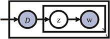
Topic Model for High Resolution Remote Sensing Data Interpretation: A Review
Zhen LI, Qiqi ZHU, Yang LEI, Jiangqin WAN... and Lei XU|Show fewer author(s)
From text analysis to image interpretation, the Topic Model (TM) consistently plays a pivotal role. With its robust semantic mining capabilities, topic model can effectively capture latent spectral and spatial information from Remote Sensing (RS) images. Recent years have seen the widespread adoption of topic models toFrom text analysis to image interpretation, the Topic Model (TM) consistently plays a pivotal role. With its robust semantic mining capabilities, topic model can effectively capture latent spectral and spatial information from Remote Sensing (RS) images. Recent years have seen the widespread adoption of topic models to address challenges in RS image interpretation, including semantic segmentation, target detection, and scene classification. Thus, clarifying and summarizing the present application status of topic models in remote sensing imagery is pivotal for advancing remote sensing image interpretation technology. This paper initially presents the foundational theory of topic models, followed by a systematic overview of their typical applications in remote sensing imagery. In addition, experimental comparisons and analyses are performed across various typical remote sensing image interpretation tasks, illustrating the extensive applicability of topic models in the realm of remote sensing and the efficacy of distinct topic models in enhancing our comprehension of remote sensing imagery. Subsequently, we have outlined the limitations of topic models and explored the potential and prospects of integrating them with deep learning..
Remote Sensing Technology and Application
- Publication Date: Jun. 20, 2024
- Vol. 39, Issue 3, 527 (2024)


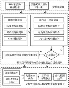
High Resolution Remote Sensing Image Change Detection Combining Adaptive Morphological Attribute Profile and Decision Fusion
Tao XIE, Shishi CHEN, Jianhua QU, and Chao WANG
With the rapid development of earth observation technology, high-resolution remote sensing image change detection has become a research hotspot in the remote sensing domain. The increase in spatial resolution brings rich spatial information, but also leads to the problem of "pseudo-change" caused by the changWith the rapid development of earth observation technology, high-resolution remote sensing image change detection has become a research hotspot in the remote sensing domain. The increase in spatial resolution brings rich spatial information, but also leads to the problem of "pseudo-change" caused by the change of the spectrum and other performance characteristics, which does not change due to phenological differences. Morphological Attribute Profiles (MAPs), as an efficient spatial information modeling method, can accurately describe complex change characteristics from different attributes and multiple scales, and have been widely used in the field of change detection tasks. Nevertheless, the existing MAPs methods usually do not consider the properties and scale balance of the differential profile, so they are prone to fall into local optimum; at the same time, the effective fusion of differential features into change detection results is another difficult problem faced by such methods. To this end, this paper proposes a change detection method that combines adaptive MAPs with decision fusion. Firstly, the initial differential feature set is extracted by CVA on the MAPs; On this basis, a Balanced Optimal Objective Function (BOF) is designed to extract the optimal differential feature set; Finally, based on the proposed change intensity evidence index (EVI) and evidence confidence index (IOEC), a multi-feature decision fusion framework is constructed to obtain change detection results. The experimental results show that the Overall Accuracy (OA) and F1 score (F1) of the proposed method can reach 96.41% and 88.67%, respectively. which are significantly better than the comparison methods in both visual analysis and quantitative evaluation. especially for the "pseudo-variation" proposed in this paper. Compared with the comparison method, the method in this paper can realize more accurate discrimination and effectively alleviate the "pseudo change"..
Remote Sensing Technology and Application
- Publication Date: Jun. 20, 2024
- Vol. 39, Issue 3, 536 (2024)
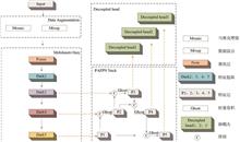
Research on Lightweight Network for Rapid Detection of Remote Sensing Image Targets based on YOLO
Wei WANG, Yong CHENG, Yuke ZHOU, Wenjie ZHANG... and Yakang GU|Show fewer author(s)
Object recognition technology based on high-resolution remote sensing images is widely used in the fields of land and resource monitoring and intelligence collection. Accurate and fast object detection methods are the hot spots and difficulties in the current research on remote sensing images. However, the current deteObject recognition technology based on high-resolution remote sensing images is widely used in the fields of land and resource monitoring and intelligence collection. Accurate and fast object detection methods are the hot spots and difficulties in the current research on remote sensing images. However, the current detection methods overly pursue improving detection accuracy while ignoring detection speed. Therefore, an improved lightweight network is proposed based on YOLOX to balance detection speed and accuracy. Firstly, for the backbone of feature extraction, a Mobilenetv3tiny is proposed to improve the detection speed by reducing the parameters of the network. Secondly, the Ghost is introduced into the feature pyramid networks to reduce the complexity of the network under the premise of ensuring detection accuracy. Finally, Alpha-IoU and VariFocal_Loss are used to optimize the loss function to improve the convergence speed and positioning accuracy of the network. The ablation experiment was carried out on the NWPU VHR-10 dataset. The results show that, compared with the baseline, the improved network has a detection accuracy increase of 0.76%, a speed increase of 19.72%, a weight of 11 M (Mega), and a parameter reduction of 65.66%. The overall effect of the improved network is better. In addition, comparative experiments on the DIOR dataset show that the detection speed is improved by 26.88% while ensuring high detection accuracy. And that proves the effectiveness of the improved network. Therefore, the improved network can effectively balance detection speed and accuracy and is easy to deploy, which makes it suitable for real-time detection of remote sensing image targets..
Remote Sensing Technology and Application
- Publication Date: Jun. 20, 2024
- Vol. 39, Issue 3, 547 (2024)
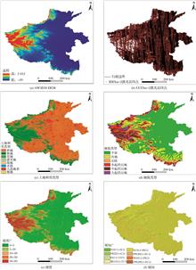
Accuracy Validation and Improvement of AW3D30 DEM Aided by ICESat-2 Data
Yinghui ZHENG, Yan ZHANG, Tao WANG, Xiang ZHAO, and Shaocong Liu
AW3D30 DEM data is one of the most widely used basic geographic information data, and its accuracy directly affects the reliability and rigor of a series of derivative products. Therefore, the accuracy validation and improvement of AW3D30 DEM data has always been a research hotspot.. However, conventional high-precisioAW3D30 DEM data is one of the most widely used basic geographic information data, and its accuracy directly affects the reliability and rigor of a series of derivative products. Therefore, the accuracy validation and improvement of AW3D30 DEM data has always been a research hotspot.. However, conventional high-precision verification data are difficult to obtain and expensive to apply in a wide range of research areas. With global coverage and sub-meter elevation accuracy, ICESat-2 data can provide reliable reference data source for AW3D30 DEM data accuracy validation and improvement. Therefore, this paper takes Henan Province as the study area, and uses ICESat-2 data to validate the elevation accuracy of AW3D30 DEM from the perspective of slope, aspect, geomorphic type and land use type and proposes the Random Forest-Long Short Term Memory Network(RF-LSTM) hybrid model to improve AW3D30 DEM. The results show that the elevation accuracy of AW3D30 DEM decreases with the increase of slope, elevation and topographic relief. The slope direction has less influence on AW3D30 DEM’s elevation accuracy, and the error distribution has no obvious regularity. The accuracy is higher in bare land and cultivated land, and worse in woodland land. The RF-LSTM hybrid model can significantly reduce the mean absolute error and root mean square error of AW3D30 DEM, improve the accuracy of AW3D30 DEM, and provide a reference for the establishment of other DEM data improvement models..
Remote Sensing Technology and Application
- Publication Date: Jun. 20, 2024
- Vol. 39, Issue 3, 557 (2024)
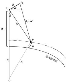
On-orbit Interferometric Data Processing Method for Spaceborne Interferometric Imaging Radar Altimeter
Shengqi SUN, Xiaojin SHI, Yunhua ZHANG, and Jiefang YANG
Interferometric Imaging Radar Altimeter(InIRA) is a new radar altimeter system, which combines synthetic aperture and interferometric measurement technologies. It can achieve two-dimensional imaging of observation areas and wide-swath height measurement by adopting small incidence angles with short baseline. Because thInterferometric Imaging Radar Altimeter(InIRA) is a new radar altimeter system, which combines synthetic aperture and interferometric measurement technologies. It can achieve two-dimensional imaging of observation areas and wide-swath height measurement by adopting small incidence angles with short baseline. Because the interferometric imaging radar altimeter works all time in orbit, the amount of raw data is so huge that it cannot be all downlinked. Block Adaptive Quantization (BAQ) algorithm is a commonly used data compression method for spaceborne Synthetic Aperture Radar (SAR), but it cannot be used for InIRA because the induced error of interferometric phase can lead to unacceptable error of Sea Surface Height (SSH) measurement and its compression ratio is also quite low. Therefore, it is of great significance to study the onboard processing algorithm that compress the raw data volume under the premise of ensuring the accuracy of SSH measurement. The major contribution of our work can be summarized as: (1) a method for image registration and flat-earth removal based on target position estimation is proposed. Compared with the orbital parameter method, this method reduces computation complexity, and can remove the rapidly changing flat-earth fringe caused by small incidence angles. (2) a multi-look method is proposed based on interpolated average, which can reduce the SSH error compared with that using uniform window size. The ocean observation data obtained by Tiangong-2 InIRA is processed using the proposed method to verify the feasibility of the on-orbit data processing method and analyze its influence on SSH measurement accuracy. The result shows that the data compression ratio of the proposed method is 46.99 at 300m×300m on-orbit resolution. The standard deviation of the phase error and height measurement error are below 0.004 9°and 0.26 cm respectively at 5 km×5 km ground resolution. Compared with BAQ, this method has the advantages of high data compression ratio and small SSH measurement error, which is more suitable for the future new generation of wide-swath InIRA on-orbit data processing..
Remote Sensing Technology and Application
- Publication Date: Jun. 20, 2024
- Vol. 39, Issue 3, 569 (2024)

A DWT-based Fusion of Inland Water Images Acquired by Tiangong-2 Interferometric Imaging Radar Altimeter
Yu CHENG, Yunhua ZHANG, Dong LI, Xiao DONG... and Wenshuai ZHAI|Show fewer author(s)
Inland water is an important resource for human beings. Tiangong-2 Interferometric Imaging Radar Altimeter (TG2-InIRA) is the first spaceborne radar altimeter which adopts the short-baseline interferometry to measure the digital elevation model of oceans and inland waters on Earth with wide swath. It is also the first Inland water is an important resource for human beings. Tiangong-2 Interferometric Imaging Radar Altimeter (TG2-InIRA) is the first spaceborne radar altimeter which adopts the short-baseline interferometry to measure the digital elevation model of oceans and inland waters on Earth with wide swath. It is also the first spaceborne imaging radar which takes an obviously small incidence to acquire the strong quasi-specular scattering of earth water. Nevertheless, the scattering of water is easily affected by observation angles and changes over time under different weather conditions, it is thus necessary to fuse the TG2-InIRA images of multi-angle and multi-temporal for a comprehensive sensing of the real state of inland water. Therefore, a Discrete Wavelet Transform (DWT)-based fusion of inland water images acquired by TG2-InIRA is proposed, where the DWT is used to decompose the to be fused source images into two components of low frequency and high frequency. Different fusion rules should be designed for these two components in view of the fact that the morphology of inland water shows great diversity in frequency domain. Specifically, a Canny operator-based fusion rule is proposed for the low-frequency components so as to highlight the global features of large water bodies such as rivers and lakes. A contrast enhancement-based fusion rule is developed for the high-frequency components so as to refine the local features such as small water bodies and water edges. Comparative experiments on two multi-angle and multi-temporal TG2-InIRA images in Anqing area with five widely-used fusion methods including the weighted averaging, the Laplace pyramid-based fusion, the non-subsampled contourlet transform-based fusion and two other DWT-based fusions demonstrate the obviously improved performance on quantitative indexes such as clarity, standard deviation, mean square error and cross-entropy. The image segmentation experiment based on the fused images further shows the nice fineness and integrity performance of the proposed approach on water body extraction..
Remote Sensing Technology and Application
- Publication Date: Jun. 20, 2024
- Vol. 39, Issue 3, 579 (2024)
Object Detection in Remote Sensing Images based on YOLOX-Tiny Biased Feature Fusion Network
Zhaohua HU, and Yuhui LI
Remote sensing target detection is of great significance in fields such as environmental monitoring and circuit inspection. However, there are challenges in remote sensing images, such as large differences in target scale, a large number of small targets, high inter class similarity and intra class diversity, which leaRemote sensing target detection is of great significance in fields such as environmental monitoring and circuit inspection. However, there are challenges in remote sensing images, such as large differences in target scale, a large number of small targets, high inter class similarity and intra class diversity, which lead to low detection accuracy. To solve the above problems, a remote sensing target detection model based on YOLOX-Tiny is proposed. Firstly, by improving the multi-scale feature fusion network to fully utilize shallow detail information and deep semantic information, the detection ability for small targets is enhanced; Secondly, deformable convolution is introduced at the prediction end to improve the robustness of the model to targets of different scales and shapes; Finally, the SIoU loss function is used to move the prediction box in the correct direction, further improving the positioning accuracy of the model. Experiments are conducted on remote sensing datasets DIOR and RSOD, and the experimental results show that without increasing the number of parameters, the improved model achieves a detection accuracy of 73.68% and 97.12%, respectively, which is high compared to some other state-of-the-art models, with a high recognition rate of overlapping targets and good real-time performance..
Remote Sensing Technology and Application
- Publication Date: Jun. 20, 2024
- Vol. 39, Issue 3, 590 (2024)
L1 Regularization based Temporal Reconstruction Method for MODIS Surface Reflectance Data
Yuhao WANG, Huanfeng SHEN, and Zhiwei LI
MODIS time series surface reflectance data is widely used in the dynamic monitoring of land surface, but the influence of factors such as cloud cover causes spatial and temporal gaps in the data, which affects the data availability. In this paper, we propose a time-domain reconstruction method based on L1 regularizatioMODIS time series surface reflectance data is widely used in the dynamic monitoring of land surface, but the influence of factors such as cloud cover causes spatial and temporal gaps in the data, which affects the data availability. In this paper, we propose a time-domain reconstruction method based on L1 regularization, which can effectively repair the gaps in MODIS surface reflectance data and realize the reconstruction of long time-series data with high accuracy. The proposed method firstly identifies the noise generated by natural and systematic factors in the time-series data, and then pre-fills the missing information region inter-annually based on noise detection. On this basis, we introduce a L1 regularization model that is more robust to abrupt noise, and construct a variational model combining the noise masks to restore the time series trend of land surface. The experimental results show that compared with SG filtering, HP filtering, L1 filtering and HANTS, the method in this paper achieves the highest reconstruction accuracy at different percentages of missing pixels of 10%, 25%, 50% and 75%, and also achieves better reconstruction results under different ground surface scenes. Therefore, this method has more advantages in both time series curves reconstruction and spatial details restoration, which shows a high practical value..
Remote Sensing Technology and Application
- Publication Date: Jun. 20, 2024
- Vol. 39, Issue 3, 603 (2024)
Recognition of Typical Objects in Chemical Industry Parks Using BASS-Net based on High-resolution Remote Sensing Images
Weiwei SUN, Jie LIU, Fangfang ZHANG, Haiyi MA... and Xianzhang PAN|Show fewer author(s)
Image processing technics is usually applied to extract typical objects in Chemical Industry Parks (CIPs). However, its precision is considered not enough for the monitoring and management of CIPs. The purpose of this study is to explore the feasibility of deep learning methods in the extraction of typical objects in CImage processing technics is usually applied to extract typical objects in Chemical Industry Parks (CIPs). However, its precision is considered not enough for the monitoring and management of CIPs. The purpose of this study is to explore the feasibility of deep learning methods in the extraction of typical objects in CIPs. This study applied convolutional neural network BASS-Net to build a typical objects recognition model of CIPs through high-resolution remote sensing images. The results showed that the overall recognition accuracy, recall rate and F1 score of the BASS-Net model for typical objects in CIPs are 97.17%,97.76% and 97.46%, and the accuracy, recall rate and F1 for each 18 typical types can reach more than 93%, which indicated that the BASS-Net trained model has the ability to classify all the typical classes in CIPs. After comparing the results with those of the RF and SVM, it can be concluded that the BASS-Net model is far superior than the other two models. The BASS-Net model can be expected to provide support for environmental monitoring and management in CIPs..
Remote Sensing Technology and Application
- Publication Date: Jun. 20, 2024
- Vol. 39, Issue 3, 612 (2024)
Coupling Mask R-CNN and Attention Mechanism for Building Extraction and Post-Processing Strategy
Buyu SU, Xiaoping DU, Haowei MU, Chen XU... and Xiaonan LUO|Show fewer author(s)
Buildings are integral components of urban areas. Extracting buildings from high-resolution remote sensing data holds significant academic importance in areas such as land use analysis, urban planning, and disaster risk reduction. For the problems of building extraction, an improved Mask R-CNN building instance segmentBuildings are integral components of urban areas. Extracting buildings from high-resolution remote sensing data holds significant academic importance in areas such as land use analysis, urban planning, and disaster risk reduction. For the problems of building extraction, an improved Mask R-CNN building instance segmentation model is proposed. Based on the residual neural network fusion convolutional attention model, a residual convolutional attention network is constructed to improve the problem of inadequate feature extraction. The loss function is optimized by adding the Dice Loss method, and then the feature learning process is optimized. And a post-processing strategy combining Douglas-Peucker algorithm and Fine polygon regularization algorithm is introduced to make the building contours more regular and smooth. The experimental results show that the improved model improves the detection mAP value by 7.74% at Iou 0.5 and 7.57% at Iou 0.75 compared with the original model, and the post-processing strategy improves the F1-Score value by 6.01% compared with the original model after selecting the appropriate threshold to optimize the mask. The instance segmentation model coupled with Mask R-CNN and attention mechanism improves the small building misdetection and omission problem, building segmentation boundary adhesion problem, and building segmentation accuracy; building post-processing strategy, improves building regularization..
Remote Sensing Technology and Application
- Publication Date: Jun. 20, 2024
- Vol. 39, Issue 3, 620 (2024)
Remote Sensing Image Target Detection based on Local Adaptive Feature Weighting Algorithm
Zilong ZHOU, Jie ZHOU, Hong LUO, Lei XU, and Genfu SHAO
Object detection in remote sensing images has become a vital aspect of the overall object detection domain. To address the problems of missed detection and false detection of small-scale objects in high-resolution remote sensing images with complex backgrounds, a local adaptive feature weighting algorithm is proposed aObject detection in remote sensing images has become a vital aspect of the overall object detection domain. To address the problems of missed detection and false detection of small-scale objects in high-resolution remote sensing images with complex backgrounds, a local adaptive feature weighting algorithm is proposed at the detection stage, combined with the YOLOv5s algorithm. By learning the existing label box information, the foreground containing target features is separated from the background, and the local features of the target with key information in the foreground are obtained. The spatial scale and weight of local features of each layer are calculated adaptively. Meanwhile, a global attention mechanism is proposed to enhance the interaction capability of cross-dimensional feature information between channels and spatial dimensions in the backbone, so as to strengthen the correlation between features and compensate for the loss of global information within local features at the detection stage, thereby reducing the rates of missed detection and false detection of targets. Experimental results show that the improved algorithm achieves certain improvements in precision and recall, with a mean average precision reaching 72.33%, representing an increase of 2.66% compared to the traditional YOLOv5s algorithm..
Remote Sensing Technology and Application
- Publication Date: Jun. 20, 2024
- Vol. 39, Issue 3, 633 (2024)
Visualization Analysis of the Development and Hot Spots of Urban Ecological Remote Sensing Research
Huimin YIN, Xiujuan HU, Lijuan YANG, Chunqiang LI, and Hanqiu XU
Taking the SCI and SSCI papers in the Web of Science (WoS) and the journal papers in the CNKI as the data source, we used bibliometrics and the literature analysis software CiteSpace to explore the development and hot spots of urban ecological remote sensing in the past three decades and drew the knowledge map of the fTaking the SCI and SSCI papers in the Web of Science (WoS) and the journal papers in the CNKI as the data source, we used bibliometrics and the literature analysis software CiteSpace to explore the development and hot spots of urban ecological remote sensing in the past three decades and drew the knowledge map of the field from 1991 to 2021. The results show that: (1) in terms of the number of publications, the research on urban ecological remote sensing has gone through three development stages, i.e., budding stage, accumulation stage, and rapid growth stage; globally, the center of centroid of the number of published papers shows a trend of migration from the east to the west and then back to the east; (2) in the light of research institutions, Institute of Geographic Sciences and Natural Resources Research, Chinese Academy of Sciences and Beijing Normal University have published most papers in this field in WoS and CNKI; (3) in terms of journals, Remote Sensing and Acta Ecologica Sinica have published most papers in this field in WoS and CNKI, respectively; (4) in terms of core authors, Weiqi Zhou in Chinese Academy of Sciences and Hanqiu Xu in Fuzhou University (China) published the most papers in WoS and CNKI, respectively; and (5) statistics of keywords shows that the keywords of ecological environment, land use, and landscape pattern were the hot spots of urban ecological remote sensing research in recent years. In general, urban ecological remote sensing was playing an increasingly important role in the disciplines of environmental science, physical geography, and geomatics. The application of remote sensing ecological models to quantitatively assess ecological environment quality has become an important trend in this field. Also, urban ecological remote sensing research requires higher and higher spatial resolution of remote sensing images. Collaborative inversion of urban ecological quality with various remote sensing images will also be a development trend in this field..
Remote Sensing Technology and Application
- Publication Date: Jun. 20, 2024
- Vol. 39, Issue 3, 642 (2024)
Exploring Urban Expending Pattern of Gansu Province Using Time Series of Nighttime Light Remote Sensing Data
Weizhe DU, ruining WANG, Weijie YU, Xingyun LIU... and Yanyun NIAN|Show fewer author(s)
Gansu Province plays an important role in the national strategies. Analyzing the regular pattern of urban expansion and temporal and spatial characteristics of Gansu Province is of great significance for the promotion of new urbanization and the implementation of Belt and Road strategy. An urban expansion model analysiGansu Province plays an important role in the national strategies. Analyzing the regular pattern of urban expansion and temporal and spatial characteristics of Gansu Province is of great significance for the promotion of new urbanization and the implementation of Belt and Road strategy. An urban expansion model analysis framework composed of standard deviation ellipse, Kernel density analysis, geometric feature analysis of built-up area, position-scale law and correlation matrix was established, and the law of urban expansion over the past 10 years was systematically evaluated based on NPP-VIIRS-like nighttime light remote sensing data corrected across sensors. First, after moving from Lanzhou City to Baiyin City, the center of gravity of nighttime light moved back again, while the distribution direction was generally northwest-southeast, with obvious agglomeration phenomenon in this direction. Secondly, the scale of cities in the province has grown significantly. Its spatial pattern evolved from the dual-core pattern of "one main and one time" in Lanzhou and Jiayuguan to Lanzhou as the center, Jiayuguan and Qingyang as the two wings. What’s more, the expansion rate of built-up areas in the province has gradually slowed down, and the expansion mode is divided into four groups related to geographical location according to the geometric characteristics of built-up areas. And then, Prefecture-level cities obey the distribution of the order-scale law, and the distribution type is secondary, which means the primacy index of the provincial capital Lanzhou City is not significant. Finally, Total amount of lights at night and the displacement of the center of gravity in the east-west direction are closely related to socio-economic factors, while the displacement in the north-south direction is not strongly correlated. Research results comprehensively reveal the law of urban expansion in Gansu Province, which has great reference value for optimizing the urban system and optimizing the pattern of land development..
Remote Sensing Technology and Application
- Publication Date: Jun. 20, 2024
- Vol. 39, Issue 3, 659 (2024)
Spatial-temporal Evolution and Influencing Factors of Drought in Different Karst Areas based on TVDI
Xianjian LU, Zhenbao LI, Hongbo YAN, Huanling ZHANG, and Ziyang GUO
Drought has an important impact on agricultural production and construction of ecological environments in karst areas. Study of drought in karst regions is of great significance for scientific drought prevention and drought relief, rock desertification management and ecological construction. The study area in this reseDrought has an important impact on agricultural production and construction of ecological environments in karst areas. Study of drought in karst regions is of great significance for scientific drought prevention and drought relief, rock desertification management and ecological construction. The study area in this research comprises Du'an, Qiaojia, and Yinjiang, which are characterized by typical karst topography. The Temperature Vegetation Drought Index (TVDI) is calculated for these areas. Spatiotemporal pattern of drought and correlation between TVDI and meteorological and topographical factors are analyzed and discussed. The results show that the study areas mainly suffered mild drought, while moderate drought were mainly distributed in zones with karst development. The drought conditions in the three areas have been improving slightly in the last 20 years, and dry stress mainly concentrated in 2001~2010. It is found that the correlation between TVDI and the average annual temperature and annual precipitation are weak or moderate, which are significantly lower than that in non-Karst areas. Negative correlations are found between TVDI in the three areas and DEM with R2 of 0.52, 0.58 and 0.67 respectively. The correlation analysis of TVDI with topographic features and DEM shows that areas with strong Karst development and widely distributed of rock fissures are more prone to drought than non-Karst areas, indicating that Karst development brings more drought stress. Furthermore, severity of the impact of Karst structure on occurrence of drought is Karst trough valley > Karst gorge > peak cluster depression. It is recommended that the impacts of the unique dualistic structure of Karst topography should be fully considered when analysing drought in Karst areas..
Remote Sensing Technology and Application
- Publication Date: Jun. 20, 2024
- Vol. 39, Issue 3, 669 (2024)
Spatial and Temporal Characteristics and Population Exposure of Heat Waves in China’s Coastal Regions
Chumzhu WEI, Yuanmei WAN, Gengzhi HUANG, Liang ZHOU, and Ying CHANG
China's coastal areas are not only the most strongly interacting zones extending from land to sea, but also the natural spatial units on the surface of the earth affected by runoff, tides and the effects of human activities and climate change. In this paper, using with the 2003~2018 high quality temporal resolutionChina's coastal areas are not only the most strongly interacting zones extending from land to sea, but also the natural spatial units on the surface of the earth affected by runoff, tides and the effects of human activities and climate change. In this paper, using with the 2003~2018 high quality temporal resolution Land Surface Temperature (LST) and Near Surface Air Temperature (NSAT) products, the spatial and temporal distribution pattern and synergy of urban heat islands and urban heat waves in coastal cities in China are systematically compared. The results show that: (1) Extreme high temperature events in China's coastal regions show a trend of increasing intensity and duration. Specifically, the intensity of urban heat islands in summer is as high as 2.25 ℃, the average heatwave frequency based on ground temperature in the entire coastal area is 24.59 times, and the temperature-based heat wave frequency is 16.33 times, accounting for 90.81% and 96.68% of the annual heat wave frequency, respectively; (2) The frequency of urban heat waves and urban heat island intensity is significantly positively correlated in the North Temperate Zone and North Subtropical Zone along the coast, and is most obvious in the North Temperate Zone. An increase of 1°C in average LST can lead to an average increase in heat wave events twice. Among them, the heat wave frequency in the North Temperate Zone increased the fastest in the three major regions, and the compound growth rate of heat wave frequency based on LST and NSAT exceeded 5%; (3) From 2003 to 2018, the urban population of China's coastal regions increased by 59%, and the number of people affected by heat waves increased by nearly 370%, exceeding 5% of the total urban population (about 40 million people). Although the urban thermal environment in China's coastal regions and the El Ni?o and La Ni?a phenomena in the sea show a more consistent distribution in time and space, how the overall urban change and population growth promote the change of high temperature and thermal environment patterns in different regions still need to be further discussed and analysed using longer time series and high spatial and spatial resolution data..
Remote Sensing Technology and Application
- Publication Date: Jun. 20, 2024
- Vol. 39, Issue 3, 679 (2024)
Spatio-temporal Dynamics and Spatial Variation of Ecological Integrity in Taiyuan based on Landscape Scale
Yuqiong SHI, and Ninglian WANG
Ecological protection and high quality development is an important national strategy in the Yellow River basin, and ecological integrity assessment is an important means of resource management and environmental protection. From the perspective of landscape ecology, this paper originally evaluate the Landscape EcologicaEcological protection and high quality development is an important national strategy in the Yellow River basin, and ecological integrity assessment is an important means of resource management and environmental protection. From the perspective of landscape ecology, this paper originally evaluate the Landscape Ecological Integrity of Taiyuan in five years (2000, 2005, 2010, 2015 and 2019) using ArcGIS software and statistical analysis software to GS + 9.0, analyze the spatio-temporal dynamics and spatial variation of Landscape Ecological Integrity. Furthermore, the temporal and spatial variation laws of landscape ecological integrity were revealed, which provided the basis for landscape ecological construction and landscape ecological planning in Taiyuan. The findings indicated that:①The LEI of Taiyuan is relatively low and in dynamic change on the whole. From the perspective of the entire city, the LEI of Taiyuan is in a dynamic change. From 2000 to 2019, the LEI can be divided into three stages;②From 2000 to 2019, the area was dominated by medium integrity. From the perspective of spatial distribution, the southeastern plain area and the urban area all in the low value range;③From 2005 to 2010 and from 2015 to 2019, there are two main stages of variation, and both of them are mainly transformed from low to medium integrity;④The overall spatial heterogeneity of LEI is relatively low in Taiyuan, which is mainly caused by spatial auto-correlation factors..
Remote Sensing Technology and Application
- Publication Date: Jun. 20, 2024
- Vol. 39, Issue 3, 690 (2024)
Application of GRACE and Meteorological Data to Monitor Terrestrial Water Storage in the Yellow River Basin
Bo ZHANG, Danping CAO, and Jiakui TANG
Providing a dynamic method to monitor water storage in the Yellow River Basin and obtaining spatial and temporal conclusions on real-time water storage changes is of great significance to the ecological protection and social development of the basin. In this study, we adopted GRACE/GRACE-FO satellite data and meteoroloProviding a dynamic method to monitor water storage in the Yellow River Basin and obtaining spatial and temporal conclusions on real-time water storage changes is of great significance to the ecological protection and social development of the basin. In this study, we adopted GRACE/GRACE-FO satellite data and meteorological station data from 2002 to 2020 in the Yellow River basin, reconstructed the missing data through multi-layer perceptual neural network. We analysed the characteristics of the Tibetan Plateau region, the Loess Plateau region, and the downstream region by combining the differences in water resources recharge, and human activities under different climatic environments. We further united the basin as a whole, and obtained the sub-districts and basin overall temporal and spatial patterns of change of terrestrial water reserves and temporal patterns of change of climate elements, and then analysed the influencing factors. The results showed as follows:①The overall land water reserves in the Yellow River Basin showed a downward trend, while the Qinghai-Tibet Plateau showed an upward trend, and the driving forces of regional water reserves were different.②There is a seasonal variation of land water reserves in different regions. There is a lag of 2~3 months between peak annual precipitation and peak annual water storage in the Loess Plateau region and downstream region, but not in the Tibetan Plateau region..
Remote Sensing Technology and Application
- Publication Date: Jun. 20, 2024
- Vol. 39, Issue 3, 699 (2024)
Extraction Method of Alpine Wetland Information Using Landsat Data
Lu CHEN, Wangping LI, Junming HAO, Zhaoye ZHOU... and Xiaoxian WANG|Show fewer author(s)
China's alpine wetlands have rich biodiversity and are one of the most productive ecosystems per unit area, as well as the most vulnerable ecosystem. Accurately extracting information from alpine wetlands is not only beneficial for improving the level of wetland dynamic change monitoring, but also of great significChina's alpine wetlands have rich biodiversity and are one of the most productive ecosystems per unit area, as well as the most vulnerable ecosystem. Accurately extracting information from alpine wetlands is not only beneficial for improving the level of wetland dynamic change monitoring, but also of great significance in protecting wetland ecosystem diversity and wetland restoration. This article takes Luqu County in the eastern section of the Qinghai Tibet Plateau as the research area. In response to the problems of low extraction accuracy and unclear optimal extraction features for different wetland types in wetland extraction based on remote sensing technology, a new wetland extraction method is proposed. Firstly, the spectral, exponential, topographic, and texture feature factors of the research area are obtained. Secondly, the Jackknife testing tool based on the maximum entropy model and GIS correlation analysis are used to rank and analyze the importance of different feature factors. The combination of feature factors is optimized by comparing the area under the ROC curve (AUC) values of the working characteristics of the subjects. Finally, the optimal feature factor combination is used as the input variable, and the Maximum Entropy coupled Discrete Particle Swarm Optimization (MEDPSO) method is used to achieve wetland extraction. The results showed that after the feature factors were optimized using the Jackknife test tool of the maximum entropy model and GIS correlation analysis, the accuracy of wetland extraction was significantly improved. The user accuracy of all wetland types reached over 90%, and the overall accuracy and Kappa coefficient were 87.56% and 0.83, respectively..
Remote Sensing Technology and Application
- Publication Date: Jun. 20, 2024
- Vol. 39, Issue 3, 708 (2024)
A Study of the Spatio-temporal Changes in Snow Cover in Northern Xinjiang from 2002 to 2020 based on MODIS Data
Yuanhong YOU, Hongze GAN, Jinliang HOU, Ruiting JIA, and Jing SUN
Northern Xinjiang is one of the three typical snow-covered regions in China. It is of great significance to explore the characteristics and rules of snow cover change in Northern Xinjiang in the context of global climate warming. In this study, the MOD10C1 and MYD10C1 data products in MODIS data were used to extract thNorthern Xinjiang is one of the three typical snow-covered regions in China. It is of great significance to explore the characteristics and rules of snow cover change in Northern Xinjiang in the context of global climate warming. In this study, the MOD10C1 and MYD10C1 data products in MODIS data were used to extract the daily snow cover products for 18 snow seasons from September 1, 2002 to May 31, 2020, obtaining information such as the number of snow days, the initial and final dates in Northern Xinjiang. Based on this, the spatial and temporal distribution characteristics and changing trends of snow cover in Northern Xinjiang were analyzed, and the correlation between snow characteristics and temperature was analyzed in conjunction with temperature data. The results showed that the average number of snow days in Northern Xinjiang was about 50~90 days, and the number of snow days in the southern mountainous areas showed a general downward trend, while the number of snow days in the central basin area showed an upward trend. The first snow day mainly concentrated between the 315 th and 330 th day, and the last snow day mainly concentrated between the 42 nd and 72 nd day. The overall change of the first snow day was small, only slightly earlier in the eastern and western border areas, and the last snow day showed an overall trend of earlier occurrence. The change in the snow-covered area of Northern Xinjiang during a single snow season showed a unimodal distribution, reaching its maximum in January. There was a significant negative correlation between the number of snow days and the last snow day and temperature, but there was a clear positive correlation between the first snow day and temperature..
Remote Sensing Technology and Application
- Publication Date: Jun. 20, 2024
- Vol. 39, Issue 3, 718 (2024)
Spatiotemporal Variation Characteristics and Influencing Factors Analysis of the GPP in the Tibetan Plateau
Hongyan LI, Xiaodan WU, Dujuan MA, Chuang WEI... and Weizhe DU|Show fewer author(s)
Scientific research on the spatio-temporal variation characteristics of surface vegetation GPP and its response to climate change is of great significance for in-depth understanding of terrestrial carbon cycle, evaluation of environmental quality of terrestrial ecosystems, and estimation of the ecological effects of fuScientific research on the spatio-temporal variation characteristics of surface vegetation GPP and its response to climate change is of great significance for in-depth understanding of terrestrial carbon cycle, evaluation of environmental quality of terrestrial ecosystems, and estimation of the ecological effects of future climate change. At present, most of the time series of GPP spatio-temporal changes on the Qinghai-Tibet Plateau are short and the spatio-temporal changes and characteristics of GPP are not deeply analyzed. Therefore, this study used linear trend detection methods to study the changes of GPP in the Tibetan Plateau between 2001 and 2019, and analyzed the response of this feature to topography and land types, while exploring the relationship between GPP and air temperature, precipitation and snow cover. The results show that the inter-annual trend of GPP on the Tibetan Plateau shows the distribution characteristics of low in northwest and high in southeast, with a maximum value of 0.23![]()
![]()
![]()
![]()
![]()
![]()
![]()
![]()
![]()
![]()
![]()
![]()
Remote Sensing Technology and Application
- Publication Date: Jun. 20, 2024
- Vol. 39, Issue 3, 727 (2024)
Dynamic Monitoring of Water Area in Dongting Lake during Flood Season based on Sentinel-1A SAR Data
Yulin ZHANG, Changbo JIANG, Yuannan LONG, and Shixiong YAN
Monitoring the dynamic changes of water area in Dongting Lake is of great significance for flood control, ecosystem stability and biodiversity. The deep learning algorithm represented by the classic Unet the innovative HRNet has become an efficient way to obtain remote sensing image information. Taking Sentinel-1A SAR Monitoring the dynamic changes of water area in Dongting Lake is of great significance for flood control, ecosystem stability and biodiversity. The deep learning algorithm represented by the classic Unet the innovative HRNet has become an efficient way to obtain remote sensing image information. Taking Sentinel-1A SAR image as the main data source, this paper qualitatively and quantitatively analyzes the water extraction results of SDWI index method (Sentinel-1 Dual-Polarized Water Index,SDWI), object-oriented classification method, UNet network model and HRNet network model. Based on the best water extraction method, the temporal and spatial variation characteristics of water area in the flood season (April to October) of Dongting Lake from 2016 to 2021 are analyzed. The results show that : ① The deep learning algorithm represented by HRNet and Unet has better water extraction effect than traditional methods. Among them, HRNet has superior performance in noise suppression and shadow resistance, and the F1 score, MRate and MIoU are 0.961 6, 0.007 8 and 0.958 6, respectively. ② During the flood season, the water area of Dongting Lake shows the characteristics of “ increase-full-decrease ” in the monthly variation. The lake surface begins to expand from April to May, and the water area maintained at a high level from June to August. Since then, due to the decrease of inflow, the water area gradually decreases from September to October. The 2 263.90 km2 at July 30, 2020 is the largest water area monitored during the study period. ③ The submerged frequency of water body in flood season of Dongting Lake gradually decreases from the center of the lake body and the main stream. The distribution patterns of submerged frequency in different lake areas are different. The submerged frequency of East Dongting Lake is higher than that of South Dongting Lake and West Dongting Lake. In summary, the combination of Sentinel-1A SAR image and deep learning technology can realize the efficient acquisition of water information and high-frequency monitoring of the water surface area at Dongting Lake, providing a new idea for the high dynamic lake water monitoring..
Remote Sensing Technology and Application
- Publication Date: Jun. 20, 2024
- Vol. 39, Issue 3, 741 (2024)
Vector Boundary Constrained Land Use Vector Polygon Change Detection Method based on Deep Learning and High-resolution Remote Sensing Images
Jiacheng SHI, Wei LIU, Pengcheng YIN, Zhaofeng CAO... and Qihua ZHANG|Show fewer author(s)
Land use vector polygons serve as crucial data reflecting the status and spatial distribution of land use. However, with the acceleration of urbanization, manual-based methods can no longer meet the current demands for precise and efficient detection of changes in land use vector polygons Therefore, this paper combinesLand use vector polygons serve as crucial data reflecting the status and spatial distribution of land use. However, with the acceleration of urbanization, manual-based methods can no longer meet the current demands for precise and efficient detection of changes in land use vector polygons Therefore, this paper combines deep learning technology, considering its requirement for a large volume of samples, and proposes an automatic change detection method for land use vector polygons under vector boundary constraints. Firstly, an improved simple linear iterative clustering algorithm is guided by the T1 vector polygons to accurately segment two periods of high-resolution imagery. Secondly, a high-quality dataset is constructed using an automatic sample generation and purification technique based on superpixels. Subsequently, an improved bilinear convolutional neural network is applied for T2 image classification. Finally, by statistically analyzing the proportion of land use type changes within the T1 vector polygons, the change detection results for land use vector polygons are derived. The experimental area is located in the Yangxi River area of Huishan District, Wuxi City, where the precision and recall rates of our method reached 87.2% and 96.1%, respectively, outperforming methods based on vector polygon feature statistics and change pixel statistics. This demonstrates the ability of our method to accurately and automatically locate changed land use vector polygons, showing broad application prospects in curbing the “non-agriculturalization” of arable land and inspecting illegal buildings..
Remote Sensing Technology and Application
- Publication Date: Jun. 20, 2024
- Vol. 39, Issue 3, 753 (2024)
Dynamic Monitoring of Ecological Quality for Hangzhou Greater Bay Area and Its Response to Land Use Cover Change Using Remote Sensing based Ecological Index
Yujun CHEN, Lingyu WANG, Yue LI, Congying GAN... and Chao SUN|Show fewer author(s)
Ecological quality monitoring and evaluation is the basis and key to carrying out ecological and environmental protection work reasonably and efficiently.Ecological quality monitoring is the basis and key process for effective ecological conservations, and it also plays an important role in ecological civilization and Ecological quality monitoring and evaluation is the basis and key to carrying out ecological and environmental protection work reasonably and efficiently.Ecological quality monitoring is the basis and key process for effective ecological conservations, and it also plays an important role in ecological civilization and high quality development of our society. In this study, we constructed a Remote Sensing based Ecological Index (RSEI) to monitor the spatio-temporal changes of ecological quality in the Hangzhou Greater Bay Area during 1995-2020. On the basis of which, we explored the quantitative relationship between ecological quality and land use types or conversions by coupling RSEI and land use data. The results showed that, (1) the overall ecological quality of Hangzhou Greater Bay Area first increased, then decreased, followed by an increase at the end. The RSEI maintained at 0.62, indicating that a relatively good ecological quality. The ecological quality of its belonging prefecture-level cities exhibited three different trends: decline, rise and fluctuation from north to south. (2) The area with improved ecological quality (57.5%) was greater than the one with degraded ecological quality (42.5%) in the Hangzhou Greater Bay Area. The forests, central urban areas and coastal wetlands were the hotspots for ecological quality imporvement, while the processes of rapid urbanization and tidal flat reclamation were responsible for degraded ecological environments. (3) In recent 25 years, the ecological quality of forest and build-up areas increased rapidly (△RSEI>+0.1), but the ecological quality of cultivated land decreased significantly (△RSEI=-0.08). This migrated the gap of ecological quality within human dominant environments, meanwile increased the ecological cost of the transformation from nature to human dominant environments. The study is expected to provide scientific basis for balancing coastal resource developments and ecological conservations, and serve for the high-quality development of coastal urban agglomerations..
Remote Sensing Technology and Application
- Publication Date: Jun. 20, 2024
- Vol. 39, Issue 3, 764 (2024)

