Jiaqi Yao1,2, Haoran Zhai2,3,*, Ren Liu2,4, Hong Zhu5..., Liuru Hu6 and Xinming Tang1,2,4|Show fewer author(s)
Author Affiliations
1College of Geomrtics, Shandong University of Science and Technology, Qingdao 266590, Shandong, China2Land Satellite Remote Sensing Application Center, Ministry of Natural Resources of P.R.China, Beijing 100048, China3College of Resource Environment and Tourism, Capital Normal University, Beijing 100048, China4School of Earth Sciences and Engineering, Hohai University, Nanjing 211100, Jiangsu, China5College of Ecology and Environment, Institute of Disaster Prevention, Langfang 065201, Hebei, China6The First Topographic Surveying Brigade, Ministry of Natural Resources of P.R.China, Xi'an 710054, Shaanxi, Chinashow less
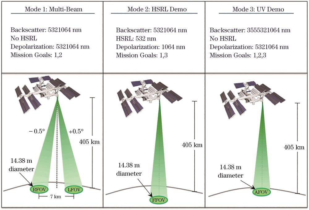
Fig. 1. Three working modes of CATS satellite
Fig. 2. Distribution of laser points on ICESat-2 satellite
[17] Fig. 3. Production flow chart of ATL04, ATL09
Fig. 4. Atmospheric detection algorithm of CATS
Fig. 5. Classification algorithm for cloud, aerosol in CATS data
Fig. 6. Flow chart of DDA algorithm
Fig. 7. Data distribution in experimental area
Fig. 8. Error analysis of experimental data.
| Project | Value |
|---|
| Wavelength of laser 1 /nm | 5321064 | | Repetition frequency of laser 1 /Hz | 5000 | | Output energy of laser 1 /mJ | ~1 | | Wavelength of laser 2 /nm | 3555321064 | | Repetition frequency of laser 2 /Hz | 4000 | | Output energy of laser 2 /mJ | ~2 | | The time of starting work | 2015.01 | | Aperture of telescope /cm | 60 | | Inclined angle of laser emission /(°) | 0.5 | | Receiving field of view /μrad | 110 | | Orbit inclination /(°) | 51 | | Orbit height /km | 405 | | Atmospheric vertical resolution /m | 60 | | Atmospheric horizontal resolution /m | 350 |
|
Table 1. Parameters of CATS satellite
| Project | Value |
|---|
| Orbit height /km | 500 | | Orbit inclination /(°) | 92 | | Orbit type | Non-solar synchronization | | Orbital period /d | 91 | | Time of starting work | 2018.09 | | Wavelength /nm | 532 | | Number of beams | 6 | | Repetition frequency of laser /Hz | 10000 | | Laser spot diameter /m | ~17 | | Output energy of laser /mJ | Strong beam:0.17 Weak beam:0.04 | | Distance between spots /km | Along-track:0.09 Cross-track(strong beam and Strong beam):3.3 Cross-track(strong beam and weak beam):2.5 | | Repetition period /d | 91 | | Elevation measurement accuracy /m | 0.1 | | Atmospheric vertical resolution /m | 30 | | Atmospheric horizontal resolution /m | 280 |
|
Table 2. Parameters of ICESat-2 satellite
| Layer type | CAD |
|---|
| Cloud | 1-10 | | Aerosol | -10--1 | | Uncertain data | 0 | | Invalid data | -999 |
|
Table 3. Atmospheric hierarchical classification based on CAD index

![Distribution of laser points on ICESat-2 satellite[17]](/richHtml/lop/2022/59/22/2228002/img_02.jpg)


