AI Video Guide
  AI Picture Guide
 AI One Sentence
Environmental perception and localization technologies are crucial for the stable operation of autonomous systems, which are increasingly prevalent in society. Of the various localization methods, simultaneous localization and mapping (SLAM) and the global navigation satellite system (GNSS) are two prominent approaches. Unlike GNSS, which relies on external position inputs, SLAM achieves localization solely through onboard sensors. In addition, SLAM can be integrated with GNSS and inertial measurement units (IMUs) to enhance overall performance.
Visual SLAM, which utilizes 2D images, initially experienced significant advancements due to improvements in camera technology. However, the susceptibility of these images to environmental factors, such as lighting variations, can compromise the accuracy of visual SLAM systems. By contrast, light detection and ranging (LiDAR) provides a more stable sensing mechanism by capturing 3D points, resulting in greater accuracy and robustness for LiDAR-based SLAM systems across varying conditions.
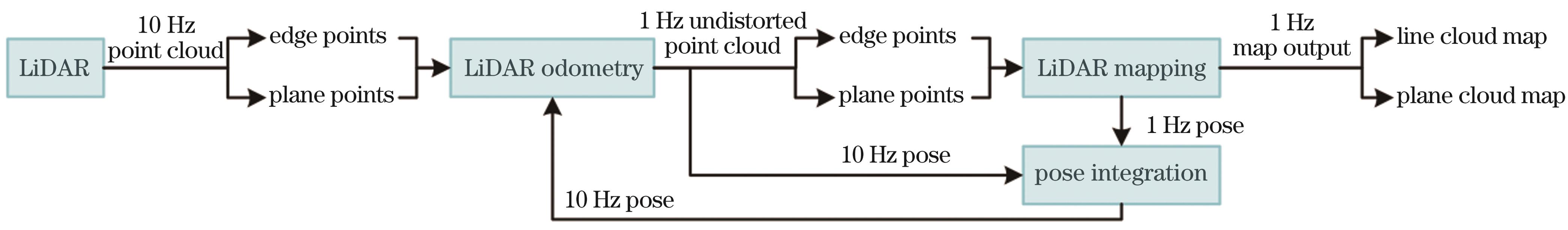
In recent years, LiDAR-based SLAM has gained widespread adoption in fields such as unmanned aerial vehicles and autonomous driving. This has led to the development of numerous LiDAR SLAM frameworks that significantly enhance both accuracy and efficiency. In LiDAR SLAM, pose estimation is achieved by aligning incoming scans with the existing map. This process involves associating scan points with the map and optimizing the pose by minimizing the overall distance between the points and geometric elements. Data association relies on the similarity of local geometric information, with the distance metric being weighted according to the corresponding uncertainty. Therefore, the accurate representation and management of local geometric information, along with effective point cloud uncertainty analysis methods, are essential for improving the precision and reliability of pose estimation. This study begins with an overview of recent advancements in LiDAR SLAM and then explores these two critical factors that influence the accuracy and efficiency of system state estimation.
Early research in LiDAR SLAM primarily focused on developing effective constraints to improve the accuracy of point cloud registration, where odometry estimation is essentially equivalent to continuous point cloud registration. LiDAR SLAM systems can be categorized into non-feature- and feature-based methods, depending on whether they extract geometric features. Both approaches emphasize the crucial role of accurately representing local geometric information to ensure the effectiveness of these constraints. Feature-based methods focus on extracting local geometric elements from the input point cloud for precise registration, while also adopting efficient strategies to maintain and update the parameters of these geometric elements within the map.
In representing and managing local geometric information within point cloud, balancing accuracy and efficiency remains a major concern in LiDAR SLAM research. Current trends include representing input scans using single-point coordinates and characterizing map local regions through geometric statistics. For map management, incremental and scale-adaptive data structures have garnered significant attention due to their efficiency and accuracy, becoming central topics of ongoing research.
As research has advanced, developing an odometry estimation system that balances accuracy and efficiency has become a priority. Tightly coupled LiDAR-inertial odometry (LIO) systems optimize the system state by integrating pose and IMU biases on the manifold, enhancing the fusion of LiDAR and IMU data and resulting in superior performance in practical applications.
Recently, some studies have introduced point cloud uncertainty analysis methods into the registration process by examining the sources of errors within the LiDAR SLAM systems, thereby achieving a reasonable weighting of the distance metric. This review explores existing LiDAR SLAM systems that utilize point-wise uncertainty models, which enhance the system's reliability and robustness compared to simply applying white Gaussian noise in the observation function, particularly in complex environments. Current research is focused on developing point-wise uncertainty models based on LiDAR measurements, the characteristics of target surfaces, and the properties of the SLAM system. In addition, some studies have investigated the mechanisms of uncertainty propagation within LiDAR SLAM systems to further improve efficiency.
To assess the effects of representing and managing geometric information and determine the impact of point cloud uncertainty analysis methods on the accuracy and efficiency of LiDAR SLAM systems, we evaluated open-source LIO systems using public datasets such as NTU VIRAL, M2DGR, and Newer College. Our comparative experiments revealed significant insights. Notably, maps that utilize statistical methods to represent local geometric information demonstrate superior accuracy. However, this improved accuracy is accompanied by increased computational complexity. In addition, integrating a well-constructed uncertainty model further enhances the accuracy of trajectory estimation.
Balancing the precision and efficiency of local geometric information representation and management within LiDAR SLAM systems remains a central focus of research efforts. The development and implementation of uncertainty models are critical, as they influence the weighting of the loss function and have thus drawn increasing attention from the research community. However, few representative achievements have emerged in the SLAM community. Thus, designing an efficient uncertainty propagation method combined with a comprehensive uncertainty model remains a major challenge in LiDAR SLAM.