• Chinese Journal of Lasers
  • Vol. 52, Issue 6, 0600003 (2025)
Kai Huang1, Junqiao Zhao2,*, and Tiantian Feng1
Author Affiliations
  • 1College of Surveying and Geo-Informatics, Tongji University, Shanghai 200092, China
  • 2School of Computer Science and Technology, Tongji University, Shanghai 200092, China
  • show less
    DOI: 10.3788/CJL241023 Cite this Article Set citation alerts
    Kai Huang, Junqiao Zhao, Tiantian Feng. Local Geometric Information Representation and Uncertainty Analysis in LiDAR SLAM[J]. Chinese Journal of Lasers, 2025, 52(6): 0600003 Copy Citation Text show less
    Illustration of the LOAM framework
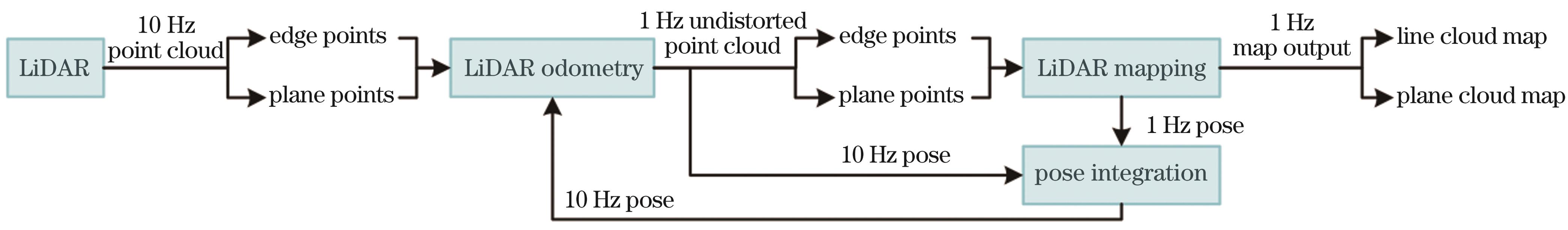
    Fig. 1. Illustration of the LOAM framework
    Illustration of the LIO framework
    Fig. 2. Illustration of the LIO framework
    Recent studies based on FAST-LIO2
    Fig. 3. Recent studies based on FAST-LIO2
    Characterization of local geometric information of single-frame point clouds in some mainstream LiDAR SLAM systems
    Fig. 4. Characterization of local geometric information of single-frame point clouds in some mainstream LiDAR SLAM systems
    Characterization of local geometric information of map in some mainstream LiDAR SLAM systems
    Fig. 5. Characterization of local geometric information of map in some mainstream LiDAR SLAM systems
    Structure of the map data in some mainstream LiDAR SLAM systems
    Fig. 6. Structure of the map data in some mainstream LiDAR SLAM systems
    Illustration of the point uncertainty model
    Fig. 7. Illustration of the point uncertainty model
    Uncertainty models of point cloud in some mainstream LiDAR SLAM systems
    Fig. 8. Uncertainty models of point cloud in some mainstream LiDAR SLAM systems
    Illustration of single-frame point cloud on NTU VIRAL sequence spms_03. The points are colored according to their uncertainty
    Fig. 9. Illustration of single-frame point cloud on NTU VIRAL sequence spms_03. The points are colored according to their uncertainty
    Mapping comparison between LOG-LIO2 and FAST-LIO2 based on localization results in the M2DGR sequence street_07 at the same point cloud resolution
    Fig. 10. Mapping comparison between LOG-LIO2 and FAST-LIO2 based on localization results in the M2DGR sequence street_07 at the same point cloud resolution
    Name of the algorithm

    Scan points

    representation

    MapUncertainty
    StructureRepresentationFactorPropagation
    FAST-LIO255Coordinateikd-treeSingle pointIsotropic noise
    Faster-LIO5780CoordinateiVOXSingle pointIsotropic noise
    Point-LIO81CoordinateiVOXSingle pointIsotropic noise
    LOG-LIO59Coordinate, normalikd-treePoints distributionIsotropic noise
    PV-LIOCoordinateAdaptive voxelPoints distributionRange, bearingBALM75
    LOG-LIO282Coordinate, normalAdaptive voxel

    Points distribution,

    normal

    Range, bearingIncremental

    Incident angle,

    roughness

    Table 1. Comparison of different LiDAR SLAM algorithms for experiments
    Dataset

    Mobile

    platform

    LiDAR

    f of

    IMU /Hz

    Ground truthEnvironmentsDuration /s
    Typef /HzMinMax
    M2DGR116Wheeled robotVelodyne-3210150RTK, 3D laser tracker

    Indoor,

    outdoor

    1271227
    NTU VIRAL122UAVOuster-16103853D laser tracker181583
    Newer College124HandheldOuster-64101006-DoF ICP1202180
    Table 2. Details of the M2DGR, NTU VIRAL, and Newer College datasets
    AlgorithmSpecified map resolutionRMSE /m
    LOG-LIO2Adaptive0.039
    PV-LIOAdaptive0.044
    LOG-LIO0.5 m0.045
    Point-LIO0.5 m0.041
    Faster-LIO0.5 m0.084
    FAST-LIO20.75 m0.047
    0.50 m0.039
    0.25 m0.045
    Table 3. Experimental results on NTU VIRAL dataset: RMSE at specified map resolutions for each algorithm
    AlgorithmSpecified map resolutionRMSE /m
    M2DGRNewer College
    LOG-LIO2Adaptive0.6260.219
    PV-LIOAdaptive0.7470.242
    LOG-LIO0.4 m0.6820.275
    Point-LIO0.4 m0.7270.266
    Faster-LIO0.4 m1.1150.237
    FAST-LIO20.6 m0.9430.254
    0.4 m1.0280.254
    0.2 m1.1100.265
    Table 4. Experimental results on M2DGR and Newer College datasets: RMSE at specified map resolutions for each algorithm
    AlgorithmSpecified map resolutionRunning time /ms
    LOG-LIO2Adaptive26.165
    PV-LIOAdaptive28.536
    LOG-LIO0.5 m28.428
    Point-LIO0.5 m11.367
    Faster-LIO0.5 m6.655
    FAST-LIO20.75 m9.017
    0.50 m12.036
    0.25 m18.036
    Table 5. Experimental results on NTU VIRAL dataset: average running time at specified map resolutions for each algorithm
    Dataset

    Specified map

    resolution

    Average running time /ms
    M2DGRNewer College
    LOG-LIO2Adaptive45.37657.820
    PV-LIOAdaptive54.61062.965
    LOG-LIO0.4 m58.31946.932
    Point-LIO0.4 m25.51425.488
    Faster-LIO0.4 m12.89414.315
    FAST-LIO20.6 m19.35016.748
    0.4 m29.03823.482
    0.2 m46.21045.677
    Table 6. Experimental results on M2DGR and Newer College datasets: RMSE at specified map resolutions for each algorithm
    Kai Huang, Junqiao Zhao, Tiantian Feng. Local Geometric Information Representation and Uncertainty Analysis in LiDAR SLAM[J]. Chinese Journal of Lasers, 2025, 52(6): 0600003
    Download Citation